Approximate Location Map
Large Map »
Latitude: 51.7524 / 51°45'8"N
Longitude: -1.2505 / 1°15'1"W
OS Eastings: 451836
OS Northings: 206238
OS Grid: SP518062
Mapcode National: GBR 8Z4.2PB
Mapcode Global: VHCXV.86SX
Plus Code: 9C3WQP2X+XR
Entry Name: 83, HIGH STREET (See details for further address information)
Listing Date: 12 January 1954
Grade: II
Source: Historic England
Source ID: 1320571
English Heritage Legacy ID: 245517
ID on this website: 101320571
Location: Oxford, Oxfordshire, OX1
County: Oxfordshire
District: Oxford
Electoral Ward/Division: Holywell
Parish: Non Civil Parish
Built-Up Area: Oxford
Traditional County: Oxfordshire
Lieutenancy Area (Ceremonial County): Oxfordshire
Church of England Parish: Oxford St Mary the Virgin with St Cross with St Peter-in-the-East,
Church of England Diocese: Oxford
Tagged with: Building
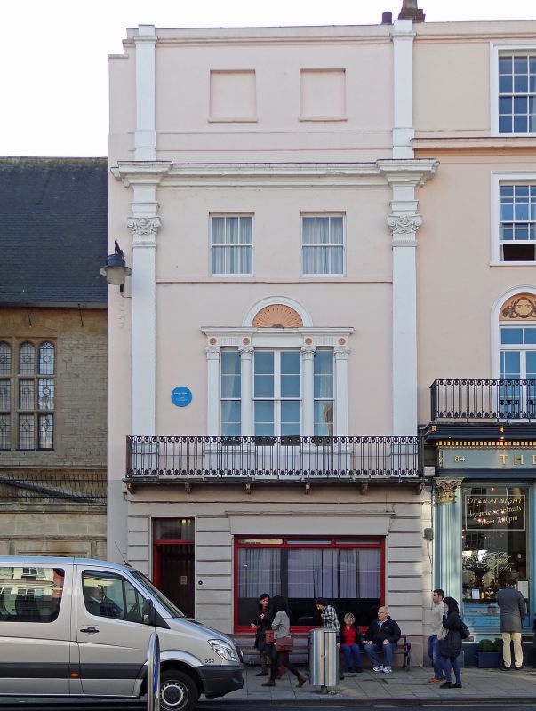
HIGH STREET
1.
1485
(South Side)
No 83 (Now part of No 84)
SP 5106 SE 9/415A 12.1.54.
II GV
2.
House and modern shop. Late C18 4-storeyed stuccoed front with cellars
and a rusticated ground floor shop. There is a moulded cornice and 2 composite
pilasters, the caps of which are carved with heads of Bacchus. Above the
cornice is the 3rd floor which has 2 blind sash windows. 4-panel door with
rectangular light over. The 1st floor has an iron balcony and a 3-light
late C18 Venetian window. There is a stone band at the 2nd floor which has
2 sash windows in plain reveals. History. A tenement here was known as
the Angel in 1552; in 1778 it has been "the principal Inn for more than a
century" ; in 1835 Queen Adelaide held a drawing room here. No 83 was the
coffee room and the rest of the inn extended eastwards on to the site of
the Examination schools but in 1828 No 84 was also part of the inn. Certain
repairs were done circa 1765 (Oxf Hist Soc LXIX (1916), 343). It ceased
to be an inn in 1866. See also ib XV (1889), 131; XXI (1892), 156; LVI
(1914) Plan VI and for leases and tenants pp. 184-6; also Boswell's Johnson
and Torington Diaries, I, 5.
All the listed buildings on the South Side form a group.
Listing NGR: SP5183106239
External links are from the relevant listing authority and, where applicable, Wikidata. Wikidata IDs may be related buildings as well as this specific building. If you want to add or update a link, you will need to do so by editing the Wikidata entry.


Other nearby listed buildings
