Approximate Location Map
Large Map »
Latitude: 51.7634 / 51°45'48"N
Longitude: -1.2686 / 1°16'7"W
OS Eastings: 450569
OS Northings: 207445
OS Grid: SP505074
Mapcode National: GBR 7XL.J27
Mapcode Global: VHCXM.YYP1
Plus Code: 9C3WQP7J+9G
Entry Name: 149-156, Kingston Road
Listing Date: 29 January 1968
Grade: II
Source: Historic England
Source ID: 1369384
English Heritage Legacy ID: 245602
ID on this website: 101369384
Location: Walton Manor, Oxford, Oxfordshire, OX2
County: Oxfordshire
District: Oxford
Electoral Ward/Division: North
Parish: Non Civil Parish
Built-Up Area: Oxford
Traditional County: Oxfordshire
Lieutenancy Area (Ceremonial County): Oxfordshire
Church of England Parish: Oxford St Philip and St James with St Margaret
Church of England Diocese: Oxford
Tagged with: Building
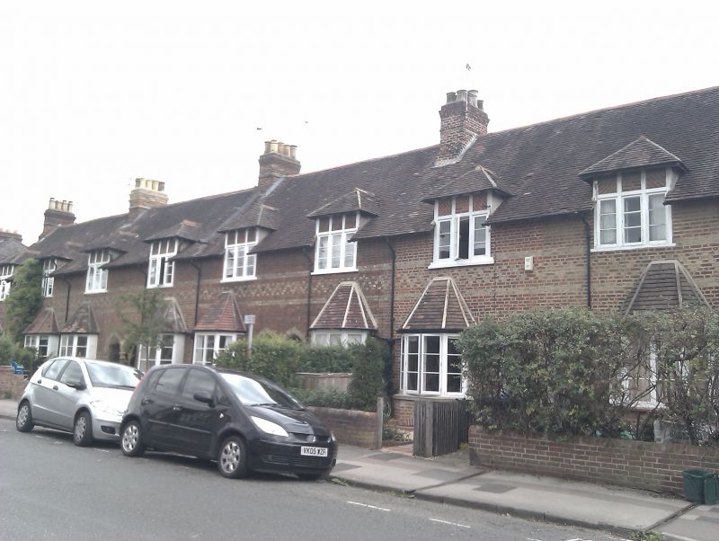
KINGSTON ROAD
1.
1485
Nos 149 to 156 (consec)
SP 5007 SE 2/97H 29.1.68.
II
2.
1870-3. By Clapton Rolfe. Polychrome brick. 1 storey and attic, with bay
windows, arched paired entrances with central column. Tiled roofs with gabled
dormers and brick stacks. (See Nos 114 to 138 (consec)).
Listing NGR: SP5056907445
External links are from the relevant listing authority and, where applicable, Wikidata. Wikidata IDs may be related buildings as well as this specific building. If you want to add or update a link, you will need to do so by editing the Wikidata entry.


Other nearby listed buildings
