Approximate Location Map
Large Map »
Latitude: 51.7587 / 51°45'31"N
Longitude: -1.261 / 1°15'39"W
OS Eastings: 451099
OS Northings: 206922
OS Grid: SP510069
Mapcode National: GBR 8YY.L0N
Mapcode Global: VHCXV.3264
Plus Code: 9C3WQP5Q+FH
Entry Name: 32, St Giles Street
Listing Date: 28 June 1972
Grade: II
Source: Historic England
Source ID: 1369417
English Heritage Legacy ID: 245830
ID on this website: 101369417
Location: Norham Manor, Oxford, Oxfordshire, OX1
County: Oxfordshire
District: Oxford
Electoral Ward/Division: Carfax
Parish: Non Civil Parish
Built-Up Area: Oxford
Traditional County: Oxfordshire
Lieutenancy Area (Ceremonial County): Oxfordshire
Church of England Parish: Oxford St Giles
Church of England Diocese: Oxford
Tagged with: Building
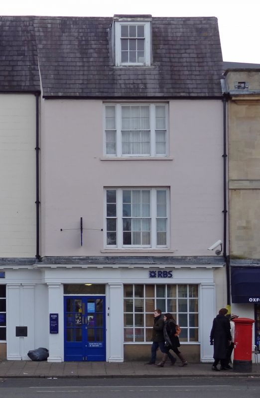
ST GILES' STREET
1.
1485
(West Side)
No 32
SP 5106 NW 5/833
II GV
2.
Late C18/Early C19. Rendered. 3 storeys, 1 window. Modern shop front on
ground floor, tripartite sashes above. Welsh slate roof.
Nos 31 to 46 (consec) and Nos 49 to 56 (consec) form a group.
Listing NGR: SP5109606932
External links are from the relevant listing authority and, where applicable, Wikidata. Wikidata IDs may be related buildings as well as this specific building. If you want to add or update a link, you will need to do so by editing the Wikidata entry.


Other nearby listed buildings
