Approximate Location Map
Large Map »
Latitude: 51.7538 / 51°45'13"N
Longitude: -1.2577 / 1°15'27"W
OS Eastings: 451337
OS Northings: 206381
OS Grid: SP513063
Mapcode National: GBR 8YY.T18
Mapcode Global: VHCXV.45ZW
Plus Code: 9C3WQP3R+GW
Entry Name: 5, Ship Street
Listing Date: 12 January 1954
Grade: II
Source: Historic England
Source ID: 1369469
English Heritage Legacy ID: 245891
ID on this website: 101369469
Location: Oxford, Oxfordshire, OX1
County: Oxfordshire
District: Oxford
Electoral Ward/Division: Carfax
Parish: Non Civil Parish
Built-Up Area: Oxford
Traditional County: Oxfordshire
Lieutenancy Area (Ceremonial County): Oxfordshire
Church of England Parish: Oxford St Michael and St Martin and All Saints
Church of England Diocese: Oxford
Tagged with: Building
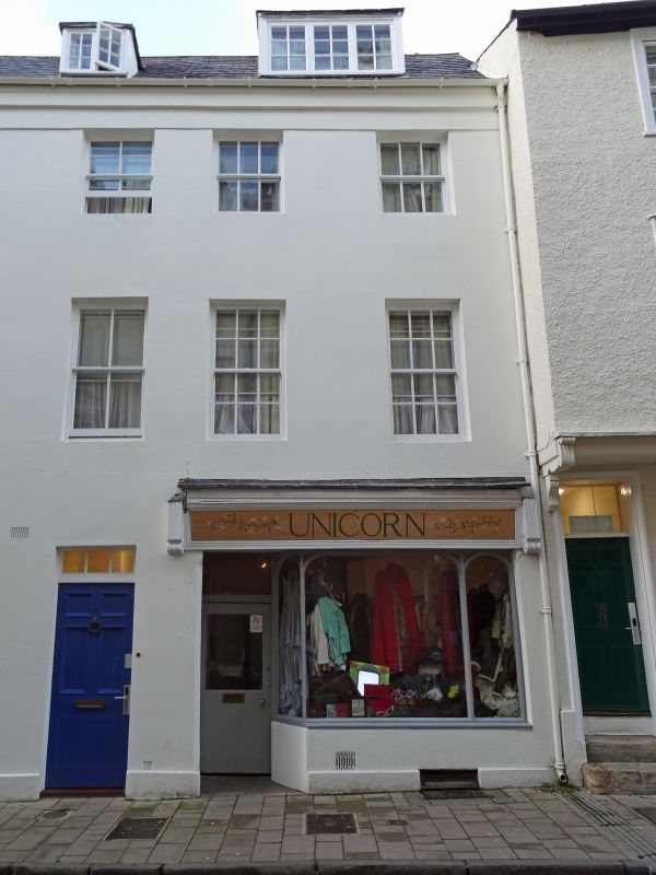
SHIP STREET
1.
1485
(North Side)
No 5
SP 5106 SW 8/162 12.1.54.
II GV
2.
House and shop. Early C18 3-storeyed stucco with cellars and a modern attic
dormer in a Welsh slate roof. In each floor are C18-C19 sash windows.
Church of St Michael, Cornmarket Street and Nos 1 to 6 (consec),
8 to 16 (consec) form a group.
Listing NGR: SP5133506384
External links are from the relevant listing authority and, where applicable, Wikidata. Wikidata IDs may be related buildings as well as this specific building. If you want to add or update a link, you will need to do so by editing the Wikidata entry.


Other nearby listed buildings
