Approximate Location Map
Large Map »
Latitude: 51.5411 / 51°32'28"N
Longitude: -0.9075 / 0°54'26"W
OS Eastings: 475864
OS Northings: 183037
OS Grid: SU758830
Mapcode National: GBR C4R.CCQ
Mapcode Global: VHDWG.7J3D
Plus Code: 9C3XG3RV+F2
Entry Name: Garden Wall of Dryden
Listing Date: 28 October 1974
Grade: II
Source: Historic England
Source ID: 1047057
English Heritage Legacy ID: 246025
ID on this website: 101047057
Location: Henley-on-Thames, South Oxfordshire, RG9
County: Oxfordshire
District: South Oxfordshire
Civil Parish: Henley-on-Thames
Built-Up Area: Henley-on-Thames
Traditional County: Oxfordshire
Lieutenancy Area (Ceremonial County): Oxfordshire
Church of England Parish: Henley-on-Thames
Church of England Diocese: Oxford
Tagged with: Wall
1.
5355
SU 7583
4/181
BADGEMORE LANE
(South Side)
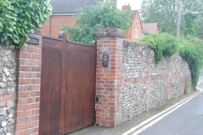
Garden wall of Dryden
II
GV
2.
1878. 7' high red brick wall with knapped flint panels and half round
red brick coping.
Nos 1 to 8 (consec) and The Barn form a group with the garden walls
of Dryden, St Audrey's and Nos 5 to 9 (consec) Baronsmead.
Listing NGR: SU7586483037
External links are from the relevant listing authority and, where applicable, Wikidata. Wikidata IDs may be related buildings as well as this specific building. If you want to add or update a link, you will need to do so by editing the Wikidata entry.


Other nearby listed buildings
