Approximate Location Map
Large Map »
Latitude: 51.5378 / 51°32'16"N
Longitude: -0.9029 / 0°54'10"W
OS Eastings: 476185
OS Northings: 182672
OS Grid: SU761826
Mapcode National: GBR C4S.DK8
Mapcode Global: VHDWG.9LJZ
Plus Code: 9C3XG3QW+4R
Entry Name: Old Armistice
Listing Date: 25 January 1951
Grade: II
Source: Historic England
Source ID: 1047791
English Heritage Legacy ID: 246190
ID on this website: 101047791
Location: Henley-on-Thames, South Oxfordshire, RG9
County: Oxfordshire
District: South Oxfordshire
Civil Parish: Henley-on-Thames
Built-Up Area: Henley-on-Thames
Traditional County: Oxfordshire
Lieutenancy Area (Ceremonial County): Oxfordshire
Church of England Parish: Henley-on-Thames
Church of England Diocese: Oxford
Tagged with: Building
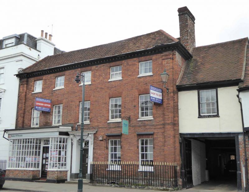
1. HART STREET
5355 (North Side)
Nos 31 & 33 (Old Armistice)
SU 7582 1/50 25.1.51.
II GV
2.
No 31 and western part of No 33 C18. Red brick with full height corner
pilasters (interrupted on western side by shop front). Moulded, modillion
wooden eaves cornice. Old tiled, hipped roof 3 storeys, 5 windows sashes
with glazing bars and gauged, flat brick arches. Central door with flat
hood on consoles, architrave and 6 panelled door with fanlight above.
Western end has had mid C19 shop front altered and now has modern door
and brick base. Entablature with dentil cornice, architrave and pilasters,
all glazing bars. Eastern side has contemporary iron railings with spearhead
finials. No 33 (Eastern part) C16 timber framed building. Facade now
stuccoed with old tiled roof. 2 storeys, 1 sash window, with glazing
bars, over carriageway arch. Heavy, 6 panelled doors to this entrance.
Nos 5 to 39 (odd), the Drinking Fountain, the Parish Church of St Mary
and the raised pavement at the east end of Hart Street, form a group associated
with Nos 2 to 8 (even) Nos 14 to 36 (even) including Adam House and Nos
40, 44 (including gates and piers) 48, No 50, The Old School House and
the Rectory Garden Wall opposite.
Listing NGR: SU7618882680
External links are from the relevant listing authority and, where applicable, Wikidata. Wikidata IDs may be related buildings as well as this specific building. If you want to add or update a link, you will need to do so by editing the Wikidata entry.


Other nearby listed buildings
