Approximate Location Map
Large Map »
Latitude: 51.5378 / 51°32'16"N
Longitude: -0.9027 / 0°54'9"W
OS Eastings: 476202
OS Northings: 182675
OS Grid: SU762826
Mapcode National: GBR C4S.DMG
Mapcode Global: VHDWG.9LNY
Plus Code: 9C3XG3QW+4W
Entry Name: 35, Hart Street
Listing Date: 25 January 1951
Grade: II
Source: Historic England
Source ID: 1291716
English Heritage Legacy ID: 246191
ID on this website: 101291716
Location: Henley-on-Thames, South Oxfordshire, RG9
County: Oxfordshire
District: South Oxfordshire
Civil Parish: Henley-on-Thames
Built-Up Area: Henley-on-Thames
Traditional County: Oxfordshire
Lieutenancy Area (Ceremonial County): Oxfordshire
Church of England Parish: Henley-on-Thames
Church of England Diocese: Oxford
Tagged with: Building
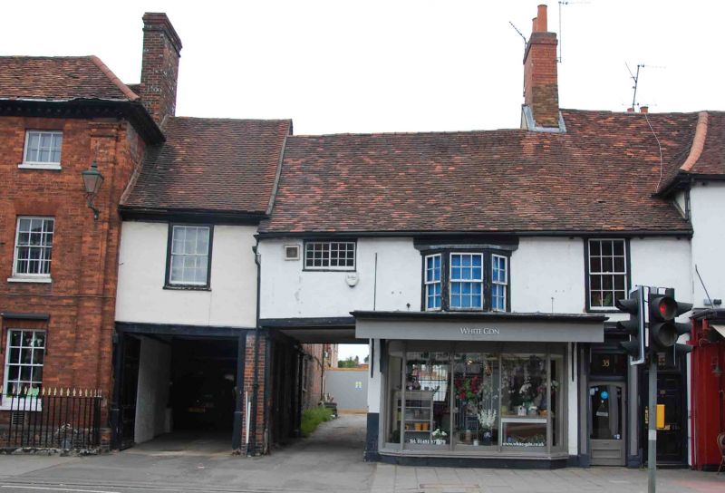
1. HART STREET
5355 (North Side)
No 35
SU 7582 1/51 25.1.51.
II GV
2.
C16 timber framed building with later additions and alterations. Stuccoed
facade with steeply pitched, irregular, old tiled roof. 2 storeys, 3
windows, 1st floor has central canted bay with cornice, sash with glazing
bars and 1 small casement, probably in original opening under eaves.
C19 shop front ground floor and carriage arch with timbered walls to west.
Nos 5 to 39 (odd), the Drinking Fountain, the Parish Church of St Mary
and the raised pavement at the east end of Hart Street, form a group associated
with Nos 2 to 8 (even) Nos 14 to 36 (even) including Adam House and Nos
40, 44 (including gates and piers) 48, No 50, The Old School House and
the Rectory Garden Wall opposite.
Listing NGR: SU7620282675
External links are from the relevant listing authority and, where applicable, Wikidata. Wikidata IDs may be related buildings as well as this specific building. If you want to add or update a link, you will need to do so by editing the Wikidata entry.


Other nearby listed buildings
