Approximate Location Map
Large Map »
Latitude: 51.5374 / 51°32'14"N
Longitude: -0.9064 / 0°54'22"W
OS Eastings: 475946
OS Northings: 182620
OS Grid: SU759826
Mapcode National: GBR C4R.KNQ
Mapcode Global: VHDWG.7MP9
Plus Code: 9C3XG3PV+XC
Entry Name: Town Hall
Listing Date: 25 January 1951
Grade: II*
Source: Historic England
Source ID: 1047802
English Heritage Legacy ID: 246213
Also known as: Henley-on-Thames Market Place
Henley Town Hall
ID on this website: 101047802
Location: Henley-on-Thames, South Oxfordshire, RG9
County: Oxfordshire
District: South Oxfordshire
Civil Parish: Henley-on-Thames
Built-Up Area: Henley-on-Thames
Traditional County: Oxfordshire
Lieutenancy Area (Ceremonial County): Oxfordshire
Church of England Parish: Henley-on-Thames
Church of England Diocese: Oxford
Tagged with: City hall Seat of local government
1. MARKET PLACE
5355
Town Hall
SU 7582 1/65 25.1.51
II GV
The Town Hall shall be upgraded to" GRADE II*"]
------------------------------------
1. MARKET PLACE
5355
Town Hall
SU 7582 1/65 25.1.51
II GV
The entry shall be amended to read:-
SU 7582 HENLEY-ON-THAMES MARKET PLACE
1/65 Town Hall
25.1.51
GV II*
------------------------------------
1. MARKET PLACE
5355
Town Hall
SU 7582 1/65 25.1.51.
II GV
2.
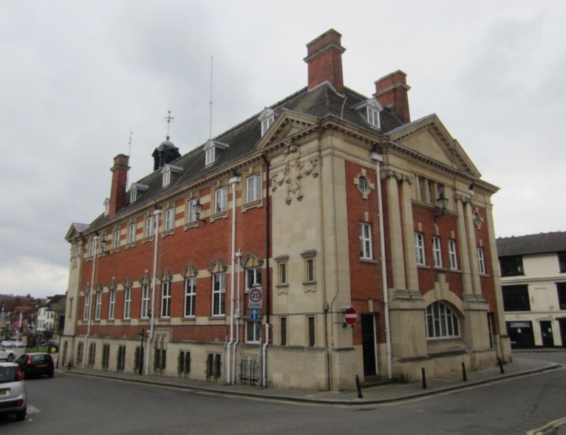
1899-1900. Architect Henry T Hare. Red brick with stone dressings.
Hipped slate roof with central cupola surmounted by gold ball and weather
vane. Central postion advanced under stone pediment with cornice and
bas relief heraldic carving in tympanum. Central Venetian window with
stone architrave breaks through eaves cornice below. Flanking double
pilasters of Ionic order above stone plinth which carries War Memorial
tablets either side of central doorway. Door set under shouldered, round
headed, stone arch and approached by a flight of steps. Narrow flanking
windows in recessed side walls in basement and floor above - otherwise
blank. This facade occupies a very prominent position in the town, closing
the western end of the vista along Hunt Street and Market Place. 11 bay
side facades. Each end advanced under pediment. Rear elevation also
with central pediment.
The Town Hall forms the focus of a group consisting of Nos 5 to 31 (odd),
No 10 and Nos 20 to 36 (even) including the barn at the rear of Nos 32
to 34 (even) Market Place. It also is part of a second Market Place group
consisting of Nos 50 to 52, Nos 62 to 66 (even) and Nos 35 to 63 (odd)
including the buildings at the rear of No 37.
Listing NGR: SU7594082622
This List entry has been amended to add sources for War Memorials Online and the War Memorials Register. These sources were not used in the compilation of this List entry but are added here as a guide for further reading, 17 August 2017.
External links are from the relevant listing authority and, where applicable, Wikidata. Wikidata IDs may be related buildings as well as this specific building. If you want to add or update a link, you will need to do so by editing the Wikidata entry.


Other nearby listed buildings
