Approximate Location Map
Large Map »
Latitude: 51.5389 / 51°32'20"N
Longitude: -0.9013 / 0°54'4"W
OS Eastings: 476296
OS Northings: 182797
OS Grid: SU762827
Mapcode National: GBR C4S.DZ1
Mapcode Global: VHDWG.BLC3
Plus Code: 9C3XG3QX+HF
Entry Name: 27-29, Thameside
Listing Date: 28 October 1974
Last Amended: 24 January 2011
Grade: II
Source: Historic England
Source ID: 1047734
English Heritage Legacy ID: 246344
ID on this website: 101047734
Location: Henley-on-Thames, South Oxfordshire, RG9
County: Oxfordshire
District: South Oxfordshire
Civil Parish: Henley-on-Thames
Built-Up Area: Henley-on-Thames
Traditional County: Oxfordshire
Lieutenancy Area (Ceremonial County): Oxfordshire
Church of England Parish: Henley-on-Thames
Church of England Diocese: Oxford
Tagged with: Building
HENLEY ON THAMES
696/1/119 THAMESIDE
28-OCT-74 (West side)
27-29
(Formerly listed as:
THAMESIDE
27-29)
GV II
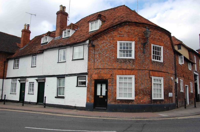
Three houses, partly mid-C15, altered and extended early C19
MATERIALS: medieval part is timber framed with street front rebuilt in brick; C19 part is wholly brick-built. All have roofs of plain clay tiles.
PLAN: No. 29 and north part of No. 28 once formed a three-bay timber-framed building, originally jettied at the northern end but now truncated by the curved remodelling of the corner bay. Original plan form unknown. South part of No. 28 and No.27 form an early C19 addition of two further bays.
EXTERIOR: No. 29 has quadrant-curved front wall of red and grey brick, mostly laid in header bond, with four-panel door to left and four multi-pane sash windows under flat-arched heads of gauged rubbed brick. Curved half-hipped roof above. Gabled kitchen extension to rear. No. 28 clad externally in painted brick, rendered to first floor, with a plank door, irregularly-placed sash and casement windows and two half-hipped dormers. Hipped end of early roof drops down to meet pitched roof of later building. Tall brick stack. No. 27 of painted and rendered brick with a plank door, casement windows and brick end stack. Nos. 27 and 28 both have modest lean-to rear extensions.
INTERIORS: Little or no early fabric at ground floor level, but parts of timber frame of unusually heavy scantling survive in first floor and attic of Nos. 28 and 29. Rear wall of No. 29 preserves original close studding with one long curved brace. Original south end wall with studwork and blocked square-mullioned window survives as internal partition in No. 28. Crown-strut roof with clasped purlins and long curved wind-braces. Dividing wall in attic between Nos. 28 and 29 preserves a complete truss, closed with studwork between tie beam and collar. Crown struts survive in adjoining trusses. Interior of No. 27 not inspected, but understood to be entirely C19.
HISTORY: The northern part of this row of houses, including No. 29 and half of No. 28, comprise the surviving part of a late-medieval timber-framed building, probably built in the mid-C15 in connexion with the river trade. The building is shown on a map of 1788 and in an engraving of c1813 - at which point it was a beer house known as the Anchor - to have had a square jettied corner bay at the intersection of Thameside and New Street. This was cut back by about half a bay for road widening in the early C19, creating the present rounded corner to No. 29. Also in the early C19 the range was extended to the south with the addition of No. 27 and what is now the southern half of No. 28. Further rear extensions were added in the later C19 and early C20.
SOURCES: Ruth Gibson, report for the Henley Archaeological and Historical Group (2010).
REASONS FOR DESIGNATION: Nos. 27-29 Thameside, a row of houses originally dating from the C15 but altered and extended in the early C19, are listed at Grade II for the following principal reasons:
* Architectural: substantial surviving portion of a C15 timber-framed building, with partial rebuilding and extension of the early C19;
* Historical: probable connection with Henley's important river trade;
* Group value: with other adjoining buildings on Thameside and New Street.
External links are from the relevant listing authority and, where applicable, Wikidata. Wikidata IDs may be related buildings as well as this specific building. If you want to add or update a link, you will need to do so by editing the Wikidata entry.


Other nearby listed buildings
