Approximate Location Map
Large Map »
Latitude: 51.5539 / 51°33'14"N
Longitude: -0.9676 / 0°58'3"W
OS Eastings: 471675
OS Northings: 184398
OS Grid: SU716843
Mapcode National: GBR C4H.G68
Mapcode Global: VHDWF.56TL
Plus Code: 9C3XH23J+HX
Entry Name: Bromsden Farmhouse, Barn Approximately 20 Metres West
Listing Date: 13 February 1985
Grade: II
Source: Historic England
Source ID: 1047422
English Heritage Legacy ID: 247024
ID on this website: 101047422
Location: South Oxfordshire, RG9
County: Oxfordshire
District: South Oxfordshire
Civil Parish: Bix and Assendon
Traditional County: Oxfordshire
Lieutenancy Area (Ceremonial County): Oxfordshire
Church of England Parish: Nettlebed with Highmoor
Church of England Diocese: Oxford
Tagged with: Barn
BIX
SU78SW
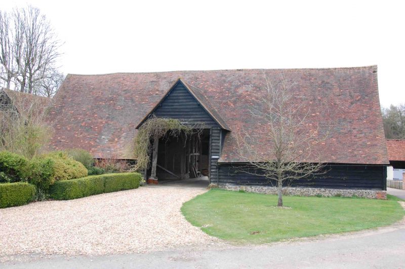
6/6 Bromsden Farmhouse, barn
approx 20 metres west.
GV II
Barn. Probably C18. Timber frame on brick plinth; weatherboarding, tile
roof. 5-bay barn, aisled to west. Central gabled entry to west and east, with
double plank doors. Jowled wall posts, double Queen-post roof.
Listing NGR: SU7167584398
External links are from the relevant listing authority and, where applicable, Wikidata. Wikidata IDs may be related buildings as well as this specific building. If you want to add or update a link, you will need to do so by editing the Wikidata entry.


Other nearby listed buildings
