Approximate Location Map
Large Map »
Latitude: 51.5752 / 51°34'30"N
Longitude: -0.9937 / 0°59'37"W
OS Eastings: 469832
OS Northings: 186740
OS Grid: SU698867
Mapcode National: GBR B2Y.1LM
Mapcode Global: VHDW6.QNJT
Plus Code: 9C3XH2G4+3G
Entry Name: Church of St Bartholomew
Listing Date: 13 February 1985
Grade: II
Source: Historic England
Source ID: 1369329
English Heritage Legacy ID: 247124
ID on this website: 101369329
Location: St Bartholomew's Church, Nettlebed, South Oxfordshire, RG9
County: Oxfordshire
District: South Oxfordshire
Civil Parish: Nettlebed
Built-Up Area: Nettlebed
Traditional County: Oxfordshire
Lieutenancy Area (Ceremonial County): Oxfordshire
Church of England Parish: Nettlebed with Highmoor
Church of England Diocese: Oxford
Tagged with: Church building
NETTLEBED HIGH STREET
SU6986
(South side)
12/102 Church of St. Bartholomew
GV II
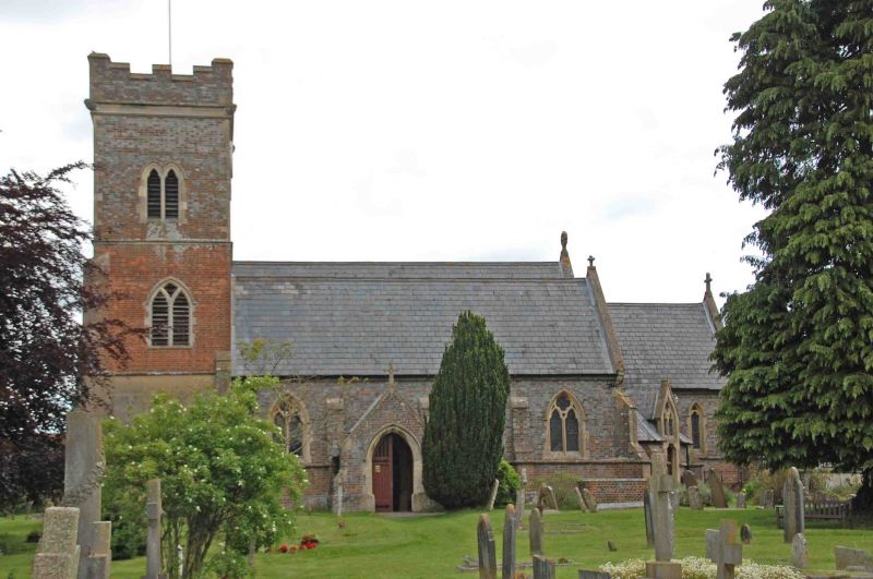
Church. Probably late C18 tower, church 1845-6 by Henry Hakewill. Grey brick
with some red brick to tower; stone window surrounds; slate roof. 4-bay nave
with south aisle, 2-bay chancel, vestry to south and west tower Early English
style. Plank door with 2 centre arch and stone surround to gabled porch with
slate roof to left of centre. Three C19 reticulated tracery windows to south
aisle, 2 lancets to chancel. 2-span roof to church. Vestry in angle between
south aisle and chancel with plank door to angle and gable above with
reticulated tracery; complex hipped roof. Tower to left of 3 stages: Plank door
to rendered ground floor; Y-tracery window to first floor; paired lancet to 2nd
floor, crenellated parapet to roof. Reticulated tracery east window.
Interior: Brass memorial plate of 1637 and good C18 stone memorials in south
aisle. Early C20 pulpit of green and cream marble. East window and western
window of south aisle by John Piper.
(Buildings of England : Oxfordshire, p.714).
Listing NGR: SU6983286740
External links are from the relevant listing authority and, where applicable, Wikidata. Wikidata IDs may be related buildings as well as this specific building. If you want to add or update a link, you will need to do so by editing the Wikidata entry.


Other nearby listed buildings
