Approximate Location Map
Large Map »
Latitude: 51.5351 / 51°32'6"N
Longitude: -0.9537 / 0°57'13"W
OS Eastings: 472667
OS Northings: 182321
OS Grid: SU726823
Mapcode National: GBR C4P.RPJ
Mapcode Global: VHDWF.FP51
Plus Code: 9C3XG2PW+3G
Entry Name: Church of St Nicholas, Chest Tomb Approximately 5 Metres East
Listing Date: 13 February 1985
Grade: II
Source: Historic England
Source ID: 1181194
English Heritage Legacy ID: 247140
ID on this website: 101181194
Location: St Nicholas Church, Rotherfield Greys, South Oxfordshire, RG9
County: Oxfordshire
District: South Oxfordshire
Civil Parish: Rotherfield Greys
Traditional County: Oxfordshire
Lieutenancy Area (Ceremonial County): Oxfordshire
Church of England Parish: Rotherfield Greys
Church of England Diocese: Oxford
Tagged with: Chest tomb
SU78SW
6/118
ROTHERFIELD GREYS
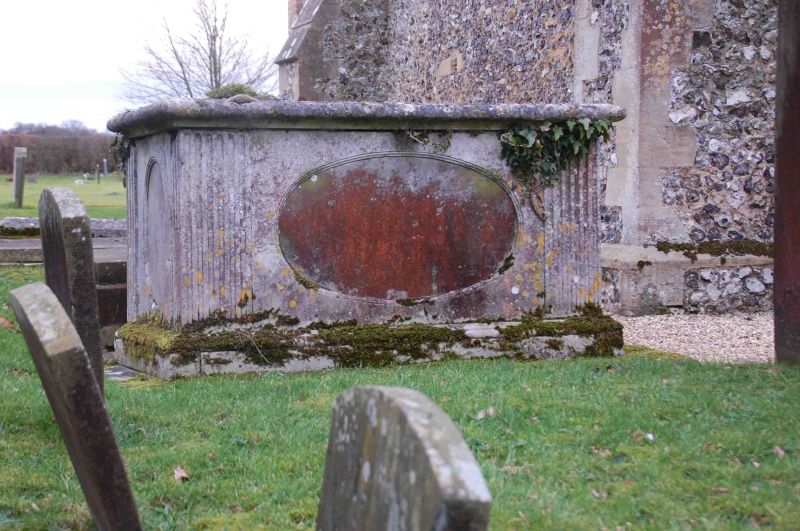
Church of St Nicholas, chest tomb approx 5 metres east
II
Chest Tomb. Circa 1795. Limestone. Rectangular with flat top. Oval panels
to centre of each side with reeded fluting to each side.
Listing NGR: SU7266782321
External links are from the relevant listing authority and, where applicable, Wikidata. Wikidata IDs may be related buildings as well as this specific building. If you want to add or update a link, you will need to do so by editing the Wikidata entry.


Other nearby listed buildings
