Approximate Location Map
Large Map »
Latitude: 51.5725 / 51°34'21"N
Longitude: -1.0763 / 1°4'34"W
OS Eastings: 464113
OS Northings: 186366
OS Grid: SU641863
Mapcode National: GBR B2T.BPR
Mapcode Global: VHCYQ.9QCW
Plus Code: 9C3WHWFF+2F
Entry Name: Barn at Poors Farm
Listing Date: 16 August 1985
Grade: II
Source: Historic England
Source ID: 1194390
English Heritage Legacy ID: 247351
ID on this website: 101194390
Location: Hailey, South Oxfordshire, OX10
County: Oxfordshire
District: South Oxfordshire
Civil Parish: Ipsden
Traditional County: Oxfordshire
Lieutenancy Area (Ceremonial County): Oxfordshire
Church of England Parish: Ipsden
Church of England Diocese: Oxford
Tagged with: Barn
SU68NW
2/133
IPSDEN
HAILEY
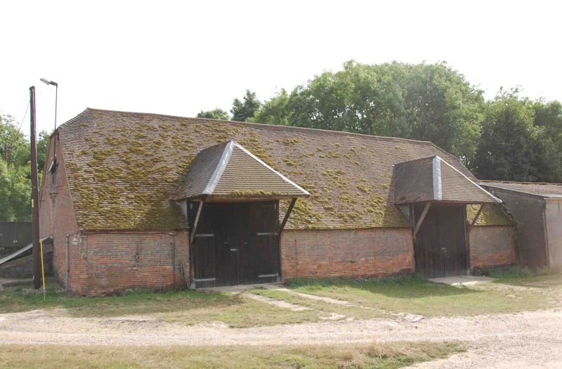
Barn at Poors Farm
II
Barn. Probably early C18. Red brick; plain tile half-hipped roof with lead
ridges. 6-bay aisled barn. Midstreys to left and right of centre with hipped
roofs on wood brackets and plank doors. Blocked ventilation slits. Curved
principal roof.
Listing NGR: SU6411386366
External links are from the relevant listing authority and, where applicable, Wikidata. Wikidata IDs may be related buildings as well as this specific building. If you want to add or update a link, you will need to do so by editing the Wikidata entry.


Other nearby listed buildings
