Approximate Location Map
Large Map »
Latitude: 51.5978 / 51°35'52"N
Longitude: -1.0294 / 1°1'45"W
OS Eastings: 467324
OS Northings: 189221
OS Grid: SU673892
Mapcode National: GBR B2H.QKJ
Mapcode Global: VHDW6.33NF
Plus Code: 9C3WHXXC+46
Entry Name: Ewelme Park Farmhouse
Listing Date: 11 December 1985
Grade: II
Source: Historic England
Source ID: 1368992
English Heritage Legacy ID: 247555
ID on this website: 101368992
Location: South Oxfordshire, RG9
County: Oxfordshire
District: South Oxfordshire
Civil Parish: Swyncombe
Traditional County: Oxfordshire
Lieutenancy Area (Ceremonial County): Oxfordshire
Church of England Parish: Swyncombe
Church of England Diocese: Oxford
Tagged with: Farmhouse
SU68NE
4/84
SWYNCOMBE
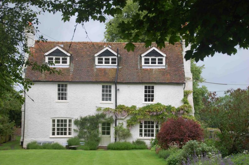
Ewelme Park Farmhouse
II
Farmhouse. Early/mid C18. Roughcast walls; old tile roof; roughcast stacks.
2-unit plan. 2 storeys and attic; 3-window range. C20 door. Late C19 sashes over
late C19 tripartite sashes. Late C19 gabled roof dormers. Gabled roof; gable end
anti external stacks. Interior: C19 doors. Chamfered beams.
Listing NGR: SU6732489221
External links are from the relevant listing authority and, where applicable, Wikidata. Wikidata IDs may be related buildings as well as this specific building. If you want to add or update a link, you will need to do so by editing the Wikidata entry.


Other nearby listed buildings
