Approximate Location Map
Large Map »
Latitude: 51.5509 / 51°33'3"N
Longitude: -1.0235 / 1°1'24"W
OS Eastings: 467805
OS Northings: 184011
OS Grid: SU678840
Mapcode National: GBR B33.L2X
Mapcode Global: VHDWD.68SX
Plus Code: 9C3WHX2G+9J
Entry Name: Church of St John the Evangelist
Listing Date: 28 November 1985
Grade: II
Source: Historic England
Source ID: 1369052
English Heritage Legacy ID: 247855
ID on this website: 101369052
Location: St John Evangelist Church, Stoke Row, South Oxfordshire, RG9
County: Oxfordshire
District: South Oxfordshire
Civil Parish: Stoke Row
Built-Up Area: Stoke Row
Traditional County: Oxfordshire
Lieutenancy Area (Ceremonial County): Oxfordshire
Church of England Parish: Stoke Row
Church of England Diocese: Oxford
Tagged with: Church building
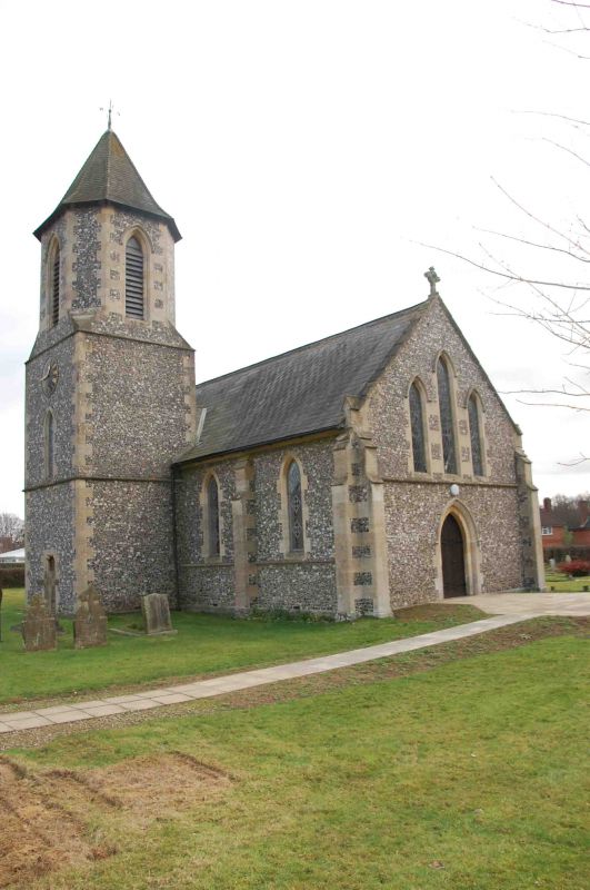
STOKE ROW
SU68SE
6/146 Church of St. John the
Evangelist
GV II
Church. c.1846. By R.C. Hussey. Knapped flint with stone dressings; Welsh slate
roof; wood shingles to roof of tower. 4-bay nave with north tower. Early English
lancet style. Central double plank door with 2-centred arch and hood-mould to
right return with triple lancet window above. Lancet to each bay between stepped
buttresses. Tower of 3 stages to left of centre. Plank door with shouldered
surround to centre of first stage. Lancet with clock face above to second stage.
Louvred lancet to principal faces of octagonal third stage. Octagonal pyramidal
roof with wind-vane. East window: 2 lancets with cartwheel tracery rose window
above. Interior: Reredos of continuous hood-mould over 6 lancet arches all with
slate panels painted with texts, except lancet windows with early C20 stained
glass to left and right of centre, C19 stained glass to rose window above. Mid
C19 quatrefoil arcade altar rail, mid C19 pews and pulpit. Mid C19 stone font
with octagonal base and chamfered sides. Coupled rafter roof with arch bracing.
(Buildings of England: Oxfordshire, p.789).
Listing NGR: SU6780584011
External links are from the relevant listing authority and, where applicable, Wikidata. Wikidata IDs may be related buildings as well as this specific building. If you want to add or update a link, you will need to do so by editing the Wikidata entry.


Other nearby listed buildings
