Approximate Location Map
Large Map »
Latitude: 51.6405 / 51°38'25"N
Longitude: -1.1029 / 1°6'10"W
OS Eastings: 462173
OS Northings: 193903
OS Grid: SU621939
Mapcode National: GBR B20.3Z5
Mapcode Global: VHCYH.T1S6
Plus Code: 9C3WJVRW+6R
Entry Name: Grace's Farmhouse
Listing Date: 14 May 1986
Grade: II
Source: Historic England
Source ID: 1047847
English Heritage Legacy ID: 248034
ID on this website: 101047847
Location: Berrick Salome, South Oxfordshire, OX10
County: Oxfordshire
District: South Oxfordshire
Civil Parish: Berrick Salome
Built-Up Area: Berrick Salome
Traditional County: Oxfordshire
Lieutenancy Area (Ceremonial County): Oxfordshire
Church of England Parish: Berrick Salome
Church of England Diocese: Oxford
Tagged with: Farmhouse
BERRICK SALOME
SU6293
10/5
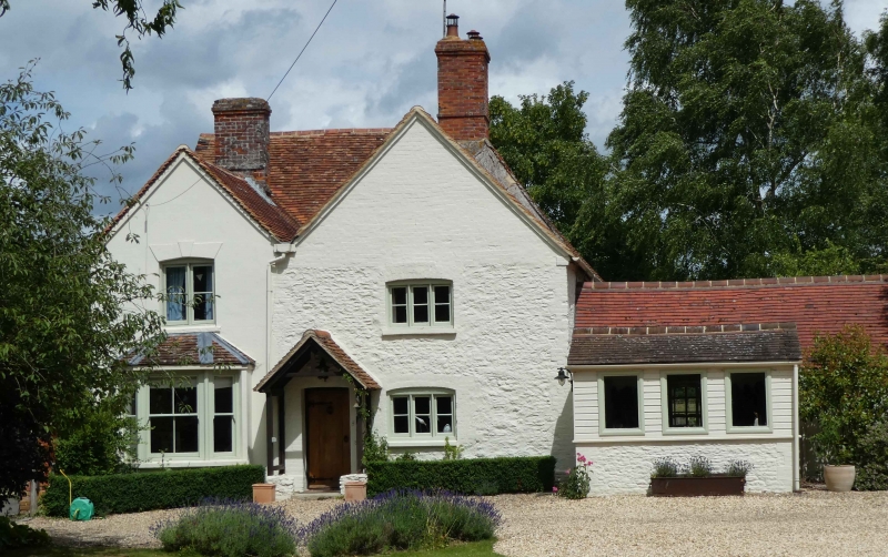
Grace's Farmhouse
II
Farmhouse, now house. Early/mid C17, altered C18 and extended C19. Colourwashed
rubble and brick dressings; old plain-tile roof with brick stacks. 2-unit plan
with double rear wing, extended. 2 storeys plus attics. 3-window front has
C18/C19 windows and no entrance, the small central windows lighting cupboards in
line with stack. Present entrance in double-gabled return to left, the rear part
of which contains a canted bay window and is a C19 infill of the L-plan. Rear
includes the M-roofed earlier rear wing. Roof of main range has large central
stack with renewed shafts. Interior: central stack has 5 brick fireplaces,
including 3 with Tudor arches in chamfered rectangular recesses; those at first
floor have panelled overmantels with brick cornices. Open-well stair in rear
wing has pierced splat balusters, knob finials, pendants and a roll-moulded
handrail. Original half of main roof has an arch-braced collar truss, 2 rows of
butt purlins and 3 rows of wind braces (2 above and one below purlins). There
are some C17 panelled doors (one dated 1655), 2 corbels dated 1663 and a beam
with double-ovolo moulding.
Listing NGR: SU6217393903
External links are from the relevant listing authority and, where applicable, Wikidata. Wikidata IDs may be related buildings as well as this specific building. If you want to add or update a link, you will need to do so by editing the Wikidata entry.


Other nearby listed buildings
