Approximate Location Map
Large Map »
Latitude: 51.6874 / 51°41'14"N
Longitude: -1.2002 / 1°12'0"W
OS Eastings: 455386
OS Northings: 199042
OS Grid: SU553990
Mapcode National: GBR 8ZZ.3CW
Mapcode Global: VHCY2.4VV9
Plus Code: 9C3WMQPX+XW
Entry Name: 36 and 37, A423
Listing Date: 18 July 1963
Grade: II
Source: Historic England
Source ID: 1286200
English Heritage Legacy ID: 248300
ID on this website: 101286200
Location: Nuneham Courtenay, South Oxfordshire, OX44
County: Oxfordshire
District: South Oxfordshire
Civil Parish: Nuneham Courtenay
Traditional County: Oxfordshire
Lieutenancy Area (Ceremonial County): Oxfordshire
Church of England Parish: Marsh Baldon with Toot Baldon and Nuneham Courtenay
Church of England Diocese: Oxford
Tagged with: Building
NUNEHAM COURTENAY A423
SU5599 (East side)
9/63 Nos.36 and 37
18/07/63
GV II
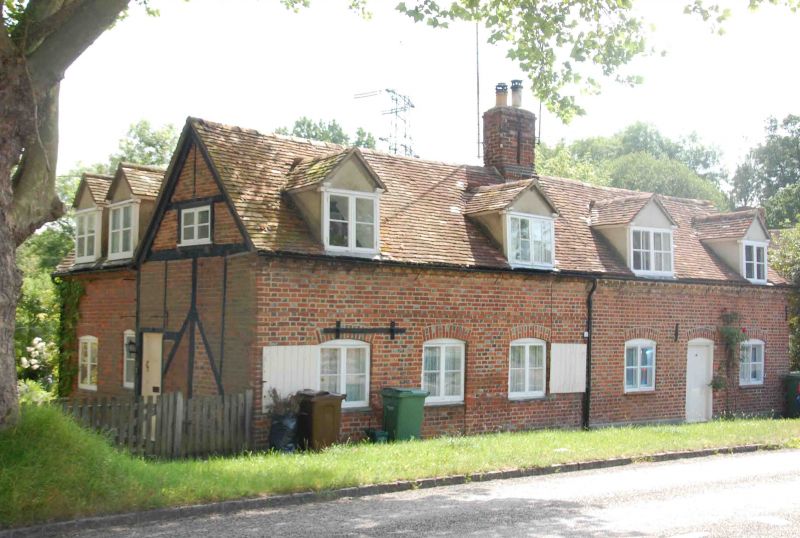
Pair of cottages. Mid C18, extended C20. Brick in Flemish bond with some flared
headers; timber framing with brick infill; old plain-tile roof with brick stack.
2-unit plans, extended to rear. One storey plus attic. 2-window cottage fronts,
in chequer brick with dentil eaves course and segmental arches, have 2-light
plank-shuttered casements flanking central doorways; the plank door to No.37 (to
right) remains but the doorway to No.36 has been built up as a casement.
Cottages have 2 gabled dormers each and share a central stack. End walls were
fully timber framed with passing braces; framing remains complete in left wall
which returns to a brick C20 extension; right wall retains main timbers only.
Interiors not inspected. Part of the estate village built c,1760 by the 1st Earl
Harcourt.
(M. Batey, "Nuneham Courtenay, an Oxfordshire C18 deserted village", Oxoniensia,
Vol.33, 1968, p.108).
Listing NGR: SU5538699042
External links are from the relevant listing authority and, where applicable, Wikidata. Wikidata IDs may be related buildings as well as this specific building. If you want to add or update a link, you will need to do so by editing the Wikidata entry.


Other nearby listed buildings
