Approximate Location Map
Large Map »
Latitude: 51.6873 / 51°41'14"N
Longitude: -1.2 / 1°12'0"W
OS Eastings: 455398
OS Northings: 199024
OS Grid: SU553990
Mapcode National: GBR 8ZZ.3G3
Mapcode Global: VHCY2.4VYF
Plus Code: 9C3WMQPX+WX
Entry Name: 38, 39 and 40, A423
Listing Date: 18 July 1963
Grade: II
Source: Historic England
Source ID: 1048038
English Heritage Legacy ID: 248301
ID on this website: 101048038
Location: Nuneham Courtenay, South Oxfordshire, OX44
County: Oxfordshire
District: South Oxfordshire
Civil Parish: Nuneham Courtenay
Traditional County: Oxfordshire
Lieutenancy Area (Ceremonial County): Oxfordshire
Church of England Parish: Marsh Baldon with Toot Baldon and Nuneham Courtenay
Church of England Diocese: Oxford
Tagged with: Building
NUNEHAM COURTENAY A423
SU5599 (East side)
9/64 Nos.38, 39 and 40
18/07/63
GV II
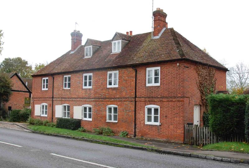
3 houses, formerly one house. Mid C18, extended and re-modelled late C19/early
C20. Brick in Flemish bond; old plain-tile roofs with brick stacks. T-shaped
plan. 2 storeys plus attic. Central 3 bays of 5-window front, with plinth,
storey band and dentil eaves course, are earlier and have 3 segmental-arched
2-light plank-shuttered casements, the central window replacing a former
doorway, plus three 2-light casements at first floor. The later outer bays have
similar windows. Hipped roof has 2 gabled roof dormers, ridge stacks flanking
earlier bays, and 2 tall stacks rising from the rear. No.38 forms a rear wing
and is an addition. Interiors not inspected. Forms the southern termination to
the village street, facing Nos.1 and 2 (q.v.), to which it was probably formerly
identical. Part of the estate village built c.1760 by the 1st Earl Harcourt.
(M. Batey, "Nuneham Courtenay, an Oxfordshire C18 deserted village", Oxoniensia
Vol.35, 19b8, p.108).
Listing NGR: SU5539899024
External links are from the relevant listing authority and, where applicable, Wikidata. Wikidata IDs may be related buildings as well as this specific building. If you want to add or update a link, you will need to do so by editing the Wikidata entry.


Other nearby listed buildings
