Approximate Location Map
Large Map »
Latitude: 51.6805 / 51°40'49"N
Longitude: -1.2177 / 1°13'3"W
OS Eastings: 454182
OS Northings: 198258
OS Grid: SU541982
Mapcode National: GBR 8ZY.QXL
Mapcode Global: VHCY7.V132
Plus Code: 9C3WMQJJ+5W
Entry Name: Pollard Memorial Approximately 15 Metres East of Church of All Saints
Listing Date: 19 August 1986
Grade: II
Source: Historic England
Source ID: 1048047
English Heritage Legacy ID: 248322
ID on this website: 101048047
Location: Lower Radley, South Oxfordshire, OX44
County: Oxfordshire
District: South Oxfordshire
Civil Parish: Nuneham Courtenay
Traditional County: Oxfordshire
Lieutenancy Area (Ceremonial County): Oxfordshire
Church of England Parish: Marsh Baldon with Toot Baldon and Nuneham Courtenay
Church of England Diocese: Oxford
Tagged with: Building
NUNEHAM COURTENAY NUNEHAM PARK
SU5498
12/85 Pollard Memorial approx. 15m.
E of Church of All Saints
GV II
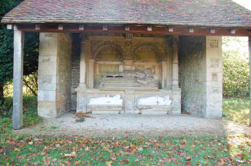
Monument. Late C16. Painted limestone. Large panelled chest tomb has 2
full-length effigies, the male raised up behind the female, and has a flat stone
canopy carried on Corinthian columns and a deep frieze carved with fruit and
swags. The soffit of the canopy is coffered and above it is strapwork cresting
with a central cartouche of arms. A further armorial cartouche is fixed to the
front of the canopy. The reredos has 2 arched recesses containing inscriptions
commemorating Sir Anthony Pollard (died 1577) and Phillippa his wife. In front
of the chest are 2 weathered effigies of children. The monument was removed to
Baldon House grounds when the medieval Church of All Saints was demolished and
was restored to Nuneham Park in the early C20. The monument is built into a C20
shelter.
(Nuneham Park is included in the HBWC County Register of Gardens at Grade I;
V.C.H.: Oxfordshire, Vol.V, p.248; Buildings of England: Oxfordshire, p.726).
Listing NGR: SU5418298258
External links are from the relevant listing authority and, where applicable, Wikidata. Wikidata IDs may be related buildings as well as this specific building. If you want to add or update a link, you will need to do so by editing the Wikidata entry.


Other nearby listed buildings
