Approximate Location Map
Large Map »
Latitude: 51.6856 / 51°41'8"N
Longitude: -1.1263 / 1°7'34"W
OS Eastings: 460493
OS Northings: 198901
OS Grid: SU604989
Mapcode National: GBR 902.B1J
Mapcode Global: VHCY3.FWDP
Plus Code: 9C3WMVPF+6F
Entry Name: Doyleys Farmhouse
Listing Date: 19 August 1986
Grade: II
Source: Historic England
Source ID: 1368766
English Heritage Legacy ID: 248392
ID on this website: 101368766
Location: Stadhampton, South Oxfordshire, OX44
County: Oxfordshire
District: South Oxfordshire
Civil Parish: Stadhampton
Traditional County: Oxfordshire
Lieutenancy Area (Ceremonial County): Oxfordshire
Church of England Parish: Stadhampton with Chiselhampton
Church of England Diocese: Oxford
Tagged with: Farmhouse
STADHAMPTON THE GREEN
SU6098 (North side)
14/158 D'0yley's Farmhouse
GV II
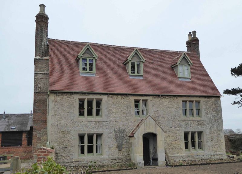
Farmhouse. Early C17, remodelled mid/late C19. Limestone rubble with ashlar
dressings, and timber framing with plaster and brick infill; old plain-tile roof
with brick gable stacks. L-plan. 2 storeys plus attics. Symmetrical 3-window
rubble front, with chamfered plinth, has a central gabled ashlar porch
sheltering a C17 doorway with a 4-centred arched ovolo-moulded surround,
recessed spandrels, and a C19 ribbed door. Outer bays have 3-light Cl9
stone-mullioned windows and there is a matching 2-light window over the porch.
Roof has 3 gabled C19 roof dormers. End walls are of rubble with remains of
timber framing at first floor, and have massive brick chimney projections, each
tapering to 2 diagonal shafts. Rear wing, returning to left, has first-floor
timber framing with heavy diagonal braces to the lower panels, and is
contemporary with the front range. Interior not inspected but likely to be of
interest. Front probably also had first-floor framing. Occupied by Timothy
D'Oyley before 1657.
(V.C.H.: Oxfordshire, Vol.VII, p.82).
Listing NGR: SU6049398901
External links are from the relevant listing authority and, where applicable, Wikidata. Wikidata IDs may be related buildings as well as this specific building. If you want to add or update a link, you will need to do so by editing the Wikidata entry.


Other nearby listed buildings
