Approximate Location Map
Large Map »
Latitude: 51.693 / 51°41'34"N
Longitude: -1.1827 / 1°10'57"W
OS Eastings: 456588
OS Northings: 199680
OS Grid: SU565996
Mapcode National: GBR 8ZT.V2R
Mapcode Global: VHCY2.GP3Z
Plus Code: 9C3WMRV8+6W
Entry Name: Hunters Gap
Listing Date: 19 August 1986
Grade: II
Source: Historic England
Source ID: 1193991
English Heritage Legacy ID: 248426
ID on this website: 101193991
Location: Marsh Baldon, South Oxfordshire, OX44
County: Oxfordshire
District: South Oxfordshire
Civil Parish: Toot Baldon
Built-Up Area: Marsh Baldon
Traditional County: Oxfordshire
Lieutenancy Area (Ceremonial County): Oxfordshire
Church of England Parish: Marsh Baldon with Toot Baldon and Nuneham Courtenay
Church of England Diocese: Oxford
Tagged with: Architectural structure Thatched cottage
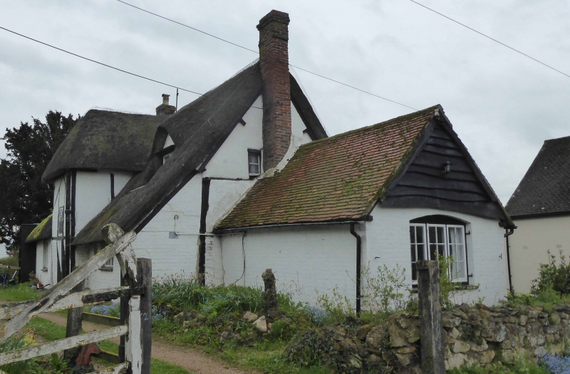
TOOT BALDON PEBBLE HILL
SU5699 (East side)
10/188 No.52 (Hunters Gap)
- II
Shown on 0.S. sheet as The Stores.
House. C17, extended C19 and C20. Timber-framing with plastered and brick
infill; thatch roof with brick gable stacks. 2-unit through-passage plan with
stair wing, extended. One storey plus attics. 2-window front has entrance to
right of centre plus a second inserted entrance to left and a casement to right;
at first floor are gabled dormers. Some first floor framing is renewed. Right
gable wall has a massive stone chimney and a large bread-oven projection. Left
gable wall has a brick chimney projection. To left, the C19 single-storey brick
and tiled extension has a plank-shuttered segmental-arched 3-light casement in
its end wall. Rear has a central timber-framed stair tower, with a hipped roof
and leaded casement, now flanked by C20 lean-to extensions. Interior: large open
fireplace with stop-chamfered bressumer and narrow-brick lining; winder stair;
clasped-purlin roof with straight wind braces (partly renewed).
Listing NGR: SU5658899680
External links are from the relevant listing authority and, where applicable, Wikidata. Wikidata IDs may be related buildings as well as this specific building. If you want to add or update a link, you will need to do so by editing the Wikidata entry.


Other nearby listed buildings
