Approximate Location Map
Large Map »
Latitude: 51.5912 / 51°35'28"N
Longitude: -1.2383 / 1°14'18"W
OS Eastings: 452860
OS Northings: 188308
OS Grid: SU528883
Mapcode National: GBR 912.5R0
Mapcode Global: VHCYM.H86K
Plus Code: 9C3WHQR6+FM
Entry Name: Kings Holme
Listing Date: 9 April 1952
Grade: II
Source: Historic England
Source ID: 1285251
English Heritage Legacy ID: 248657
ID on this website: 101285251
Location: East Hagbourne, South Oxfordshire, OX11
County: Oxfordshire
District: South Oxfordshire
Civil Parish: East Hagbourne
Built-Up Area: Didcot
Traditional County: Berkshire
Lieutenancy Area (Ceremonial County): Oxfordshire
Church of England Parish: Hagbourne
Church of England Diocese: Oxford
Tagged with: Architectural structure
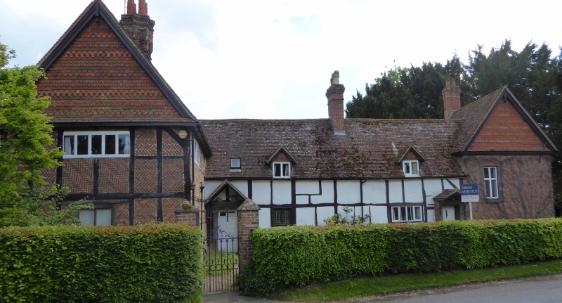
EAST HAGBOURNE MAIN ROAD
SU5288 (South side)
14/44 No.5 (Kings Holme)
09/04/52
GV II
House. C16, mid C17 cross-wing to left, C19 addition to right.
Cruck-framed,large timber-framing to centre with rendered infill; large
timber-framing with brick infill in herringbone pattern to cross-wing to left;
C19 red brick to right; old plain-tile roof to cross-wing; late C20 plain-tile
roof to centre and right; brick ridge stacks. Single storey and attic; 2-window
range to centre, 2-storey cross-wing to left, 2-storey C19 addition to right.
8-panel part-glazed door with porch with re-used timber-frame to left. 6-panel
door with porch with re-used timber-frame to right. 4-light casement to right of
centre. 2-light wood mullion window with moulded wood surround to left of
centre. 2 gabled dormers. 5-light wood mullion windows to right return and first
floor end of cross-wing. French window to end of cross-wing. C19 irregular
fenestration to right. Noted as having 3 full cruck trusses.
Listing NGR: SU5286088308
External links are from the relevant listing authority and, where applicable, Wikidata. Wikidata IDs may be related buildings as well as this specific building. If you want to add or update a link, you will need to do so by editing the Wikidata entry.


Other nearby listed buildings
