Approximate Location Map
Large Map »
Latitude: 51.6716 / 51°40'17"N
Longitude: -0.9668 / 0°58'0"W
OS Eastings: 471547
OS Northings: 197490
OS Grid: SU715974
Mapcode National: GBR C34.2DX
Mapcode Global: VHDVV.678V
Plus Code: 9C3XM2CM+M7
Entry Name: Town Farmhouse and Attached Wall
Listing Date: 3 April 1987
Grade: II
Source: Historic England
Source ID: 1059716
English Heritage Legacy ID: 248951
ID on this website: 101059716
Location: Lewknor, South Oxfordshire, OX49
County: Oxfordshire
District: South Oxfordshire
Civil Parish: Lewknor
Built-Up Area: Lewknor
Traditional County: Oxfordshire
Lieutenancy Area (Ceremonial County): Oxfordshire
Church of England Parish: Lewknor
Church of England Diocese: Oxford
Tagged with: Farmhouse
LEWKNOR HIGH STREET
SU7197 (South side)
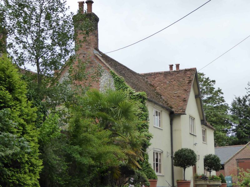
10/105 Town Farmhouse and attached
wall
GV II
Farmhouse. Early/mid C16, extended to sides c.1790. Originally timber-framed.
Rendered front: sides and rear of flint rubble with brick dressings. Gabled
M-shaped old tile roof; brick symmetrical end stacks and large rear lateral
stacks. Double-depth plan. 2 storeys; symmetrical 3-window range. Central gabled
projecting bay has C20 leaded window over segmental arched C20 door: flanking
bays have 3-light leaded casements except C19 three-light casement to lower
left. One-storey brewhouse to right of flint rubble with brick dressings, gabled
old tile roof, and C18 plank door flanked by 3-light leaded casements. Interior:
C16 house in centre has exposed timber framing and 3-bay queen-post roof with
curved windbraces and clasped purlins. Subsidiary features: L-shaped wall to
left of front, of flint and rubble with vertical brick dressings.
(Oxfordshire Country Museum, Woodstock, PRN 4040).
Listing NGR: SU7154797490
External links are from the relevant listing authority and, where applicable, Wikidata. Wikidata IDs may be related buildings as well as this specific building. If you want to add or update a link, you will need to do so by editing the Wikidata entry.


Other nearby listed buildings
