Approximate Location Map
Large Map »
Latitude: 51.6036 / 51°36'12"N
Longitude: -1.1211 / 1°7'15"W
OS Eastings: 460965
OS Northings: 189781
OS Grid: SU609897
Mapcode National: GBR 911.KC3
Mapcode Global: VHCYH.JY5L
Plus Code: 9C3WJV3H+CH
Entry Name: Fragment of Castle Wall at Su 6096 8978
Listing Date: 9 December 1949
Grade: I
Source: Historic England
Source ID: 1181852
English Heritage Legacy ID: 249216
ID on this website: 101181852
Location: Wallingford, South Oxfordshire, OX10
County: Oxfordshire
District: South Oxfordshire
Civil Parish: Wallingford
Built-Up Area: Wallingford
Traditional County: Berkshire
Lieutenancy Area (Ceremonial County): Oxfordshire
Tagged with: Architectural structure
WALLINGFORD CASTLE LANE
SU6089NE (East side)
Wallingford
10/57 Fragment of Castle wall at
09/12/49 SU 6096 8978
(Formerly listed as Remains of
Queen's Tower and fragments of
Castle Wall)
GV I
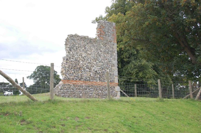
Fragment of Castle wall. Probably C13. Coursed squared limestone to south face;
knapped flint with stone dressings to north face. Approx. 6m. long and 6m. high.
History: Wallingford Castle was begun in 1067 by order of William the Conqueror;
supervised by Robert D'Oyley. Motte and Bailey castle completed in 1071. Castle
expanded in C13 under King John, and King Henry III, when it was held by
Richard, Earl of Cornwall. In 1307 the castle and town were given by Edward II
to Piers Gaveston, created Baron Wallingford. In 1335 Edward II gave the castle
to his son Edward, the Black Prince, Duke of Cornwall, who spent large sums on
repairs and improvements. Held during most of C15 by Chaucer and dela Pole
families of Ewelme. By 1540's the castle had fallen into disrepair and stone was
being used for other buildings in the town. During the Civil War it was
fortified as a Royalist stronghold. Charles I inspected the new works in 1643.
Siege of Wallingford in 1646 when Colonel Blagge was besieged for 16 weeks by
Cromwell's troops. On 17th November 1652 Cromwell's Council of State ordered its
demolition. This fragment probably formerd part of the Inner Bailey. The Castle
area is scheduled as an ancient monument.
("Wallingford Castle, a brief guide", 1984; V.C.H.: Berkshire, Vol.III, 1923,
p.523-531; Buildings of England: Berkshire, 1966, p.248).
Listing NGR: SU6096089780
External links are from the relevant listing authority and, where applicable, Wikidata. Wikidata IDs may be related buildings as well as this specific building. If you want to add or update a link, you will need to do so by editing the Wikidata entry.


Other nearby listed buildings
