Approximate Location Map
Large Map »
Latitude: 51.6013 / 51°36'4"N
Longitude: -1.1287 / 1°7'43"W
OS Eastings: 460440
OS Northings: 189521
OS Grid: SU604895
Mapcode National: GBR 911.HG3
Mapcode Global: VHCYP.D04S
Plus Code: 9C3WJV2C+GG
Entry Name: Wall Approximately 20 Metres North East of the Cross Keys Public House
Listing Date: 9 February 1988
Grade: II
Source: Historic England
Source ID: 1284608
English Heritage Legacy ID: 249258
ID on this website: 101284608
Location: Wallingford, South Oxfordshire, OX10
County: Oxfordshire
District: South Oxfordshire
Civil Parish: Wallingford
Built-Up Area: Wallingford
Traditional County: Berkshire
Lieutenancy Area (Ceremonial County): Oxfordshire
Tagged with: Wall
WALLINGFORD HIGH STREET
SU6089 (North side)
Wallingford
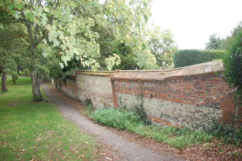
7/90 Wall approx. 20m. NE of No.48
(The Cross Keys Public House)
GV II
Wall. C18. Knapped flint wall with brick dressings and angled brick coping. Wall
approx. 3m. high and 25m. long. Included for group value.
Listing NGR: SU6044089521
External links are from the relevant listing authority and, where applicable, Wikidata. Wikidata IDs may be related buildings as well as this specific building. If you want to add or update a link, you will need to do so by editing the Wikidata entry.


Other nearby listed buildings
