Approximate Location Map
Large Map »
Latitude: 51.5992 / 51°35'57"N
Longitude: -1.1248 / 1°7'29"W
OS Eastings: 460712
OS Northings: 189290
OS Grid: SU607892
Mapcode National: GBR 911.QFR
Mapcode Global: VHCYP.G26D
Plus Code: 9C3WHVXG+M3
Entry Name: Hammers Oxfam Shop
Listing Date: 9 December 1949
Last Amended: 9 February 1988
Grade: II
Source: Historic England
Source ID: 1368503
English Heritage Legacy ID: 249318
ID on this website: 101368503
Location: Wallingford, South Oxfordshire, OX10
County: Oxfordshire
District: South Oxfordshire
Civil Parish: Wallingford
Built-Up Area: Wallingford
Traditional County: Berkshire
Lieutenancy Area (Ceremonial County): Oxfordshire
Tagged with: Architectural structure
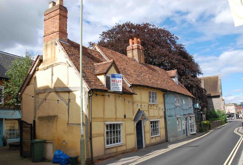
WALLINGFORD ST. MARY,S STREET
(West side)
SU6089SE Nos.52 (Hammers) and 53 (Oxfam
Shop)
11/152 (Formerly listed as No.52 (The
09/12/49 Gabled Cottage) and No.55)
GV II
House, now shops with dwellings+ Mid C17 with C20alterations. Rendered plinth;
render, probably on timber framing; old plain-tile roof; brick ridge stack to
left of centre. Probably 3-unit lobby-entry plan, now altered. 2 storeys and
attic; 3-window range. 4-panel door with gabled hood on brackets to right of
centre. Sash door with gabled hood on brackets to left+ C20 at-roofed bow
window to right. 16-pane unhorned sash to centre. 16-pane window to left of
centre. 3-light wood casement to first floor left. 2-light wood casements to
first floor centre and right. Gabled dormer with 2-light casement 'to right.
Right return; timber framing with brick infill to first floor. Queen post roof
truss to gable end. Interior: open fireplace to ground floor centre, and
extensive beaming to interior. Single-storey-and-attic, single-window C18
addition to left.C19 shop window to ground floor. Gabled dormer with 3-light
casement.
Listing NGR: SU6071289290
External links are from the relevant listing authority and, where applicable, Wikidata. Wikidata IDs may be related buildings as well as this specific building. If you want to add or update a link, you will need to do so by editing the Wikidata entry.


Other nearby listed buildings
