Approximate Location Map
Large Map »
Latitude: 51.5987 / 51°35'55"N
Longitude: -1.1225 / 1°7'21"W
OS Eastings: 460873
OS Northings: 189236
OS Grid: SU608892
Mapcode National: GBR 911.R0S
Mapcode Global: VHCYP.H2FS
Plus Code: 9C3WHVXG+FX
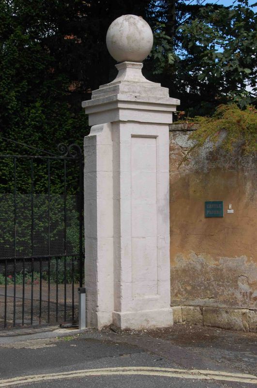
Entry Name: Gatepier Approximately 20 Metres South East of Castle Priory College
Listing Date: 9 February 1988
Grade: II
Source: Historic England
Source ID: 1368507
English Heritage Legacy ID: 249336
ID on this website: 101368507
Location: Wallingford, South Oxfordshire, OX10
County: Oxfordshire
District: South Oxfordshire
Civil Parish: Wallingford
Built-Up Area: Wallingford
Traditional County: Berkshire
Lieutenancy Area (Ceremonial County): Oxfordshire
Tagged with: Gatepost
SU6089SE
11/169
WALLINGFORD
THAMES STREET
(East side)
Wallingford
Gatepier approx. 20m, SE of Castle Priory College
GV
II
Gatepier. Probably early C19. Painted stone. Square pier with recessed panels to
front and sides. Ball finial. Included for group value.
Listing NGR: SU6087389236
External links are from the relevant listing authority and, where applicable, Wikidata. Wikidata IDs may be related buildings as well as this specific building. If you want to add or update a link, you will need to do so by editing the Wikidata entry.


Other nearby listed buildings
