Approximate Location Map
Large Map »
Latitude: 51.6581 / 51°39'29"N
Longitude: -1.5846 / 1°35'4"W
OS Eastings: 428829
OS Northings: 195565
OS Grid: SU288955
Mapcode National: GBR 5VP.VL0
Mapcode Global: VHC0L.HL47
Plus Code: 9C3WMC58+75
Entry Name: 8-10, Cornmarket
Listing Date: 10 July 1986
Grade: II
Source: Historic England
Source ID: 1368494
English Heritage Legacy ID: 249373
ID on this website: 101368494
Location: Faringdon, Vale of White Horse, Oxfordshire, SN7
County: Oxfordshire
District: Vale of White Horse
Civil Parish: Great Faringdon
Built-Up Area: Faringdon
Traditional County: Berkshire
Lieutenancy Area (Ceremonial County): Oxfordshire
Church of England Parish: Faringdon
Church of England Diocese: Oxford
Tagged with: Building
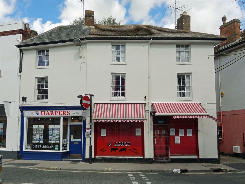
GREAT FARINGDON CORNMARKET
SU 2895
3/47 Nos 8 to 10 (consecutive)
-
GV II
c.1840 row of 3 stucco faced houses on curve. Hipped slate shallow-pitched
eaves roof. One ridge stack. 3 storeys, one window range each. Centre house,
No 9, slightly projected. Glazing bar sash windows and ground floor C19 and
modern shopfronts.
Listing NGR: SU2882595567
External links are from the relevant listing authority and, where applicable, Wikidata. Wikidata IDs may be related buildings as well as this specific building. If you want to add or update a link, you will need to do so by editing the Wikidata entry.


Other nearby listed buildings
