Approximate Location Map
Large Map »
Latitude: 51.6584 / 51°39'30"N
Longitude: -1.5873 / 1°35'14"W
OS Eastings: 428646
OS Northings: 195589
OS Grid: SU286955
Mapcode National: GBR 5VP.TTP
Mapcode Global: VHC0L.FLQ1
Plus Code: 9C3WMC57+83
Entry Name: The Elms
Listing Date: 10 July 1986
Grade: II
Source: Historic England
Source ID: 1048459
English Heritage Legacy ID: 249381
ID on this website: 101048459
Location: Faringdon, Vale of White Horse, Oxfordshire, SN7
County: Oxfordshire
District: Vale of White Horse
Civil Parish: Great Faringdon
Built-Up Area: Faringdon
Traditional County: Berkshire
Lieutenancy Area (Ceremonial County): Oxfordshire
Church of England Parish: Faringdon
Church of England Diocese: Oxford
Tagged with: Building
This list entry was subject to a Minor Amendment on 17 February 2022 to update the name and address and to reformat the text to current standards
SU 2895
3/11
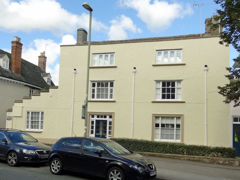
GREAT FARINGDON
GLOUCESTER STREET (north side)
The Elms
(Formerly listed as No 26 (The Elms))
II
Early to mid C18 house altered and refaced in early C19. Rubble stone with cement rendered front. Two-storey and attic with plain tile roof and east end wall stack. South front, two-window range, three-storey with parapet. Sash windows with margin lights and stone sills. Stone surrounds to ground floor window and door. Stone plinth. Added lean-to extension to west side with similar window and stepped parapet.
Interior: earlier C18 wood staircase in entrance hall with panelled ends to treads and brackets beneath. Turned balusters. Two fielded panelled doors. East side ground floor room panelled with moulded dado rail and cornice and one semicircular niche. Rendered rear wing, with larger mid C19 rear extension beyond. Marble fireplace to ground floor room.
Listing NGR: SU2864695589
External links are from the relevant listing authority and, where applicable, Wikidata. Wikidata IDs may be related buildings as well as this specific building. If you want to add or update a link, you will need to do so by editing the Wikidata entry.


Other nearby listed buildings
