Approximate Location Map
Large Map »
Latitude: 51.6587 / 51°39'31"N
Longitude: -1.5834 / 1°35'0"W
OS Eastings: 428913
OS Northings: 195626
OS Grid: SU289956
Mapcode National: GBR 5VP.VYF
Mapcode Global: VHC0L.HKST
Plus Code: 9C3WMC58+FJ
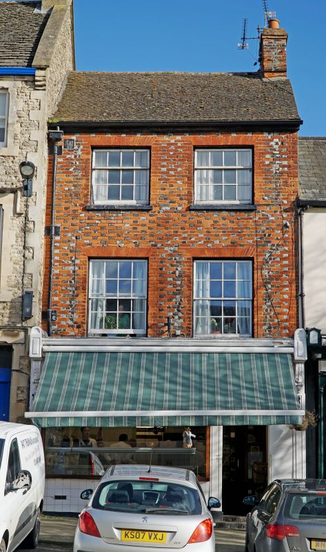
Entry Name: 3, Market Place
Listing Date: 10 July 1986
Grade: II
Source: Historic England
Source ID: 1199592
English Heritage Legacy ID: 249440
ID on this website: 101199592
Location: Faringdon, Vale of White Horse, Oxfordshire, SN7
County: Oxfordshire
District: Vale of White Horse
Civil Parish: Great Faringdon
Built-Up Area: Faringdon
Traditional County: Berkshire
Lieutenancy Area (Ceremonial County): Oxfordshire
Church of England Parish: Faringdon
Church of England Diocese: Oxford
Tagged with: Building
GREAT FARINGDON MARKET PLACE
SU 2895
3/50 No 3
-
GV II
Earlier C19 chequered brick house, 3-storey with plain tile roof and south end
wall stack. 2-window range, glazing bar sashes with gauged brick flat heads to
surrounds. Altered later C19 projecting shopfront with moulded brackets to
fascia.
Listing NGR: SU2891595627
External links are from the relevant listing authority and, where applicable, Wikidata. Wikidata IDs may be related buildings as well as this specific building. If you want to add or update a link, you will need to do so by editing the Wikidata entry.


Other nearby listed buildings
