Approximate Location Map
Large Map »
Latitude: 51.6572 / 51°39'25"N
Longitude: -1.5855 / 1°35'7"W
OS Eastings: 428768
OS Northings: 195459
OS Grid: SU287954
Mapcode National: GBR 5VW.1YX
Mapcode Global: VHC0L.GLNY
Plus Code: 9C3WMC47+VQ
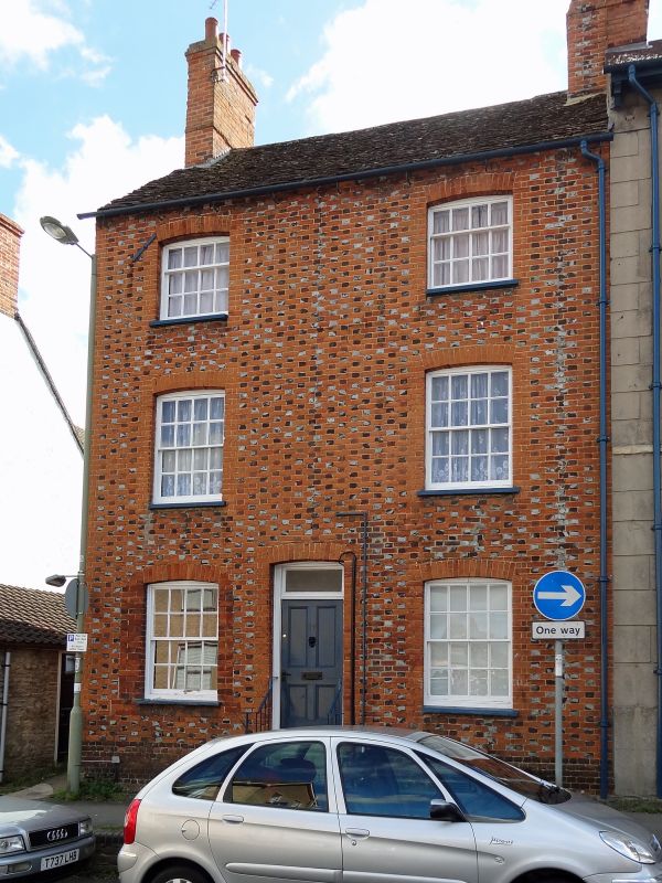
Entry Name: 17, Marlborough Street
Listing Date: 10 July 1986
Grade: II
Source: Historic England
Source ID: 1048409
English Heritage Legacy ID: 249463
ID on this website: 101048409
Location: Faringdon, Vale of White Horse, Oxfordshire, SN7
County: Oxfordshire
District: Vale of White Horse
Civil Parish: Great Faringdon
Built-Up Area: Faringdon
Traditional County: Berkshire
Lieutenancy Area (Ceremonial County): Oxfordshire
Church of England Parish: Faringdon
Church of England Diocese: Oxford
Tagged with: Building
GREAT FARINGDON MARLBOROUGH STREET
SU 2895
3/41 No 17
-
GV II
Earlier C19 chequered brick house. 3-storey and basement. Stone tiled roof
with end wall stacks. 2-window range of 16-pane sash windows in cambered head
surrounds. Central door, rectangular fanlight. 3 steps up. Rubble stone rear
and modern extensions.
Listing NGR: SU2876895459
External links are from the relevant listing authority and, where applicable, Wikidata. Wikidata IDs may be related buildings as well as this specific building. If you want to add or update a link, you will need to do so by editing the Wikidata entry.


Other nearby listed buildings
