Approximate Location Map
Large Map »
Latitude: 51.7112 / 51°42'40"N
Longitude: -1.3601 / 1°21'36"W
OS Eastings: 444307
OS Northings: 201578
OS Grid: SP443015
Mapcode National: GBR 7Y1.QY0
Mapcode Global: VHCXZ.C8T1
Plus Code: 9C3WPJ6Q+FX
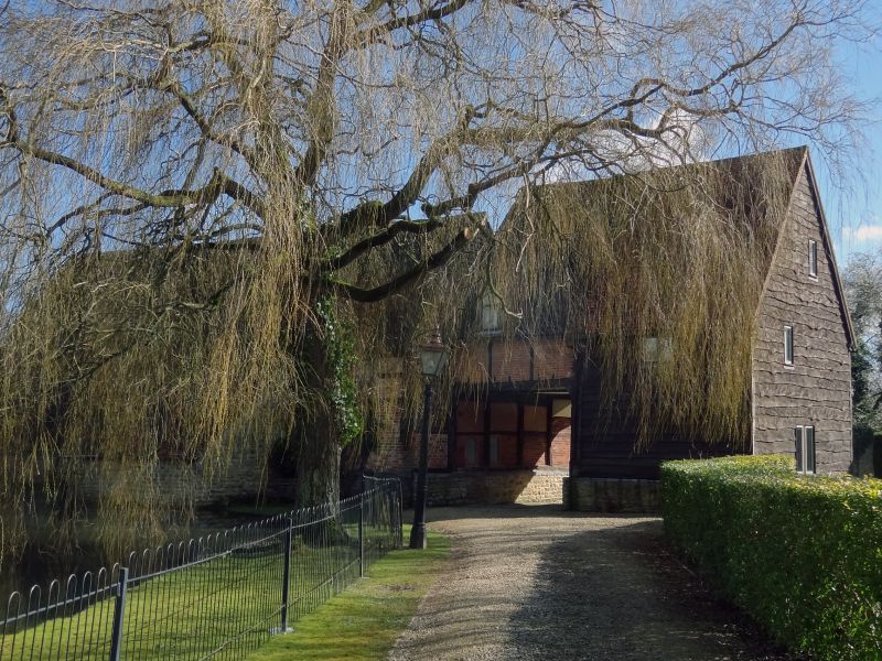
Entry Name: Manor Barn with Gatehouse and Attached Walls Approximately 85 Metres North West of Appleton Manor
Listing Date: 6 August 1952
Last Amended: 6 July 1987
Grade: II
Source: Historic England
Source ID: 1048428
English Heritage Legacy ID: 249511
ID on this website: 101048428
Location: Appleton, Vale of White Horse, Oxfordshire, OX13
County: Oxfordshire
District: Vale of White Horse
Civil Parish: Appleton-with-Eaton
Built-Up Area: Appleton
Traditional County: Berkshire
Lieutenancy Area (Ceremonial County): Oxfordshire
Church of England Parish: Appleton
Church of England Diocese: Oxford
Tagged with: Barn
This list entry was subject to a Minor Amendment on 29/08/2012
SP4401
9/14
06/08/52
APPLETON WITH EATON
EATON ROAD
(East side)
Appleton
Manor Barn with gatehouse and attached walls approx. 85m NW of Appleton Manor
(Formerly listed as Barn with gatehouse and attached walls approx. 85m NW of Appleton Manor)
(Formerly listed as No.16 (Appleton Manor House) including barn)
GV
II
Barn and gatehouse, now store. Late C16/early C17. Barn: C20 weatherboarding over timber framing on limestone plinth: 4 square panels to each bay; square timber framing with brick infill to rear. Gabled Marseilles tile roof. Plank doors in outer bays, C20 to left and C18 with old strap hinges to right. Outshut of limestone rubble to rear. Interior: 5-bay collar-truss roof with windbraces, butt purlins and braced posts. Gatehouse to left: 2 storeys; one bay of similar materials with gabled old tile roof and through-entry. Subsidiary features: C18 walls attached to right of barn enclose kitchen garden. Limestone rubble wall with brick courses at top carried c.90m. along Church Road and then returned to meet a plainer limestone rubble wall which is returned to the barn, thus
enclosing kitchen garden. (Buildings of England: Berkshire, p.66).
Listing NGR: SP4430701578
External links are from the relevant listing authority and, where applicable, Wikidata. Wikidata IDs may be related buildings as well as this specific building. If you want to add or update a link, you will need to do so by editing the Wikidata entry.


Other nearby listed buildings
