Approximate Location Map
Large Map »
Latitude: 51.5696 / 51°34'10"N
Longitude: -1.2356 / 1°14'8"W
OS Eastings: 453075
OS Northings: 185909
OS Grid: SU530859
Mapcode National: GBR 919.DG1
Mapcode Global: VHCYM.JTN4
Plus Code: 9C3WHQ97+RQ
Entry Name: Almshouse Approximately 40 Metres West of Church of Saint Michael
Listing Date: 16 February 1979
Last Amended: 5 May 1988
Grade: II
Source: Historic England
Source ID: 1368626
English Heritage Legacy ID: 249886
ID on this website: 101368626
Location: Blewbury, Vale of White Horse, Oxfordshire, OX11
County: Oxfordshire
District: Vale of White Horse
Civil Parish: Blewbury
Built-Up Area: Blewbury
Traditional County: Berkshire
Lieutenancy Area (Ceremonial County): Oxfordshire
Church of England Parish: Blewbury
Church of England Diocese: Oxford
Tagged with: Almshouse
This list entry was subject to a Minor Amendment on 30/08/2012
SU5385
16/25
16/02/79
BLEWBURY
CHURCH ROAD
(North-east side)
Almshouse approx. 40m W of Church of Saint Michael
(Formerly listed as: Almshouse approx. 40m SW of the parish Church, Church Street)
GV II
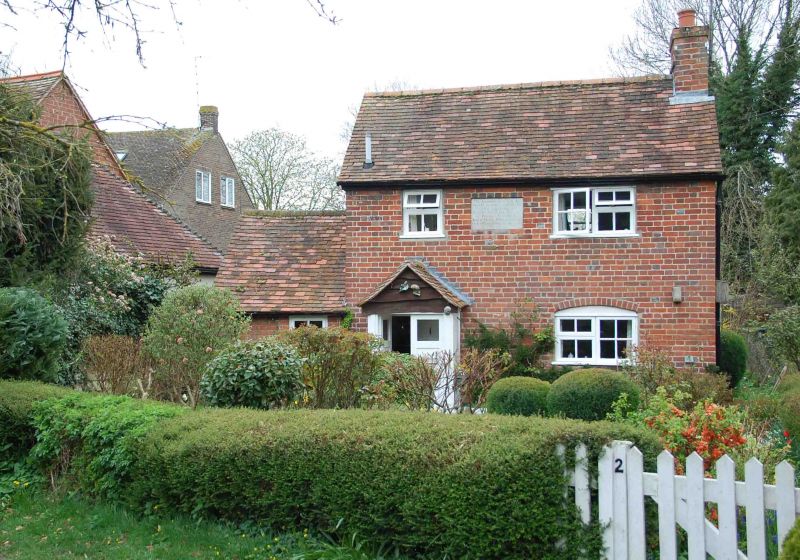
Almshouse. Dated 1837 to inscription. Red brick with random flared bricks in
Flemish bond; old plain-tile roof; brick end stack to right. 2-storey, 2-window
range. C20 plank double-leaf outer door to C2O gabled porch. Plank inner door.
C20 two-light casement to right with segmental brick head C20 two-light
casement to first floor right. C20 single-light casement to first floor left.
Inscribed stone panel to first floor centre reads "The ground on which this
house is erected and the garden adjoining was kindly given for (the use?) of
Bacon's Charity by John Shawe Philips of Culham, Oxon in the year 1837",
Interior not inspected. Included for group value.
Listing NGR: SU5307585909
External links are from the relevant listing authority and, where applicable, Wikidata. Wikidata IDs may be related buildings as well as this specific building. If you want to add or update a link, you will need to do so by editing the Wikidata entry.


Other nearby listed buildings
