Approximate Location Map
Large Map »
Latitude: 51.5981 / 51°35'53"N
Longitude: -1.6583 / 1°39'29"W
OS Eastings: 423767
OS Northings: 188864
OS Grid: SU237888
Mapcode National: GBR 5WC.MLJ
Mapcode Global: VHC0Y.63P6
Plus Code: 9C3WH8XR+7M
Entry Name: The Memorial Hall
Listing Date: 31 October 1983
Grade: II
Source: Historic England
Source ID: 1048794
English Heritage Legacy ID: 250590
ID on this website: 101048794
Location: Shrivenham, Vale of White Horse, Oxfordshire, SN6
County: Oxfordshire
District: Vale of White Horse
Civil Parish: Shrivenham
Built-Up Area: Shrivenham
Traditional County: Berkshire
Lieutenancy Area (Ceremonial County): Oxfordshire
Church of England Parish: Shrivenham with Watchfield and Bourton
Church of England Diocese: Oxford
Tagged with: Building
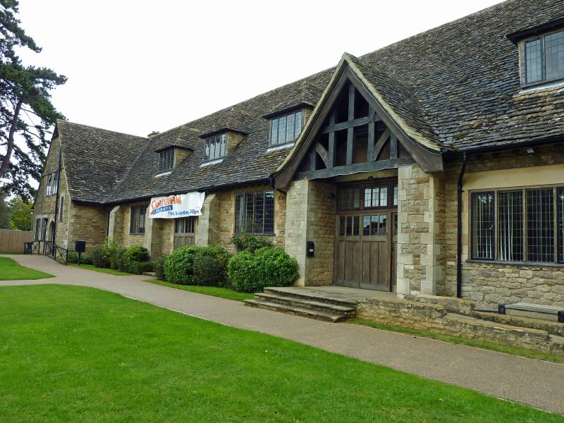
1. SHRIVENHAM HIGHWORTH ROAD
(east side)
The Memorial Hall
SG 2388 7/56
II
2.
1921-5 in Cotswold Arts and Crafts style, possibly by John B Thorp, London firm of
architects who made a model for the building in 1921 which survives in the clerk's
office. Built of coursed and squared rubble stone and dressed stone quoins and
openings with a wide sweep of gabled stone tiled roof and tall end stone stacks.
I storey and attic with a SW front comprising a 3 bay half tile-hung gabled end to the
it (the caretaker's quarters) adjoining a 5 bay range whose 4th bay is a gabled
entrance with open timber framing in the apex. The roof of this main section has
4 hipped stone tiled dormers with 4 leaded lights to each and similar windows to the
ground floor. The W wall has 2 polygonal bay windows. Built onto the rear is a C20
cricket pavilion.
Inside the main congregation area has a wooden hammer-beam roof and there are several
Perp style chimney pieces with oak leaf spandrels in adjoining rooms. Set back from
the main road at the Swindon entrance to Shrivenham, the hall occupies an important
visual site in the villagescape.
Listing NGR: SU2376788864
External links are from the relevant listing authority and, where applicable, Wikidata. Wikidata IDs may be related buildings as well as this specific building. If you want to add or update a link, you will need to do so by editing the Wikidata entry.


Other nearby listed buildings
