Approximate Location Map
Large Map »
Latitude: 51.6277 / 51°37'39"N
Longitude: -1.6585 / 1°39'30"W
OS Eastings: 423738
OS Northings: 192152
OS Grid: SU237921
Mapcode National: GBR 5VZ.TT7
Mapcode Global: VHC0R.6CL1
Plus Code: 9C3WJ8HR+3J
Entry Name: Strattenborough Castle
Listing Date: 31 October 1983
Grade: II
Source: Historic England
Source ID: 1368372
English Heritage Legacy ID: 250619
ID on this website: 101368372
Location: Vale of White Horse, Oxfordshire, SN6
County: Oxfordshire
District: Vale of White Horse
Civil Parish: Watchfield
Traditional County: Berkshire
Lieutenancy Area (Ceremonial County): Wiltshire
Church of England Parish: Shrivenham with Watchfield and Bourton
Church of England Diocese: Oxford
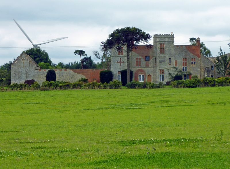
1. WATCHFIELD HIGHWORTH ROAD
Strattenborough Castle
SU 29 SW 1/80
II
2.
Dated 1792 on the N front to the left of the main door above a ground floor window
Built to double as a working farm and a Gothick eye-catcher for Coleshill House.
Rubble stone and brick with dressed stone quoins and openings. The farmhouse faces
its yard to the S, but its N front rises above the dwelling's roofline to form a wall
with 2 castellated projecting sham towers, one square the other polygonal. The
combination of materials suggests either a late C18 sensitivity to the organic growth
of a building: brick additions to an earlier, stone structure or a complete
rehabilitation at a much later date. The whole N facade is punctuated by mullioned
and cross mullioned windows, some blind, others with 9 pane sashes. Other features
include single and cruciform arrowslits, elaborate string coursing and stone arched
surrounds with brick infil. A wall from the main block links it on the E with a
stepped gabled barn. This is symmetrically balanced to the W by another, larger, barn
with a gabled stone tiled roof which is set further back and has a N end with an
enormous sham window of 5 lights, partly ruinous, all bricked in . Below this
'window' is a genuine C11 Norman tympanum and above it, set in brick, the date 1794.
Listing NGR: SU2373892152
External links are from the relevant listing authority and, where applicable, Wikidata. Wikidata IDs may be related buildings as well as this specific building. If you want to add or update a link, you will need to do so by editing the Wikidata entry.


Other nearby listed buildings
