Approximate Location Map
Large Map »
Latitude: 51.6778 / 51°40'40"N
Longitude: -1.5051 / 1°30'18"W
OS Eastings: 434316
OS Northings: 197784
OS Grid: SU343977
Mapcode National: GBR 6WX.Q9T
Mapcode Global: VHC0M.V3P4
Plus Code: 9C3WMFHV+4X
Entry Name: Pump Approximately 5 Metres West of Numbers 1 and 2 New Row
Listing Date: 15 January 1986
Grade: II
Source: Historic England
Source ID: 1368405
English Heritage Legacy ID: 250889
ID on this website: 101368405
Location: Buckland, Vale of White Horse, Oxfordshire, SN7
County: Oxfordshire
District: Vale of White Horse
Civil Parish: Buckland
Built-Up Area: Buckland
Traditional County: Berkshire
Lieutenancy Area (Ceremonial County): Oxfordshire
Church of England Parish: Gainfield
Church of England Diocese: Oxford
Tagged with: Pump
BUCKLAND BUCKLAND ROAD
(East side)
SU3497
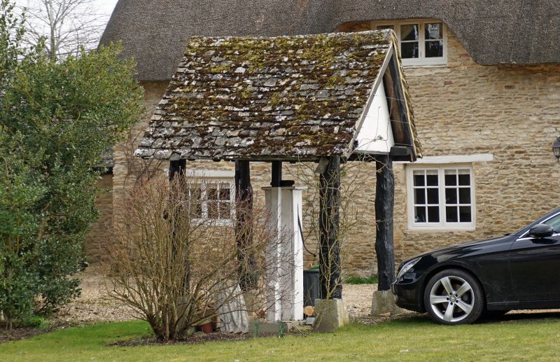
8/60 Pump approx. 5m. W of Nos. 1
and 2 New Row
GV II
Pump and shelter. Late C19. Cast iron pump. Shelter has gabled stone slate roof
and is supported on pine log posts. Included for group value.
Listing NGR: SU3431697784
External links are from the relevant listing authority and, where applicable, Wikidata. Wikidata IDs may be related buildings as well as this specific building. If you want to add or update a link, you will need to do so by editing the Wikidata entry.


Other nearby listed buildings
