Approximate Location Map
Large Map »
Latitude: 51.6316 / 51°37'53"N
Longitude: -1.5053 / 1°30'19"W
OS Eastings: 434336
OS Northings: 192650
OS Grid: SU343926
Mapcode National: GBR 6XH.Q70
Mapcode Global: VHC0T.V8K1
Plus Code: 9C3WJFJV+JV
Entry Name: Milestone
Listing Date: 15 January 1986
Grade: II
Source: Historic England
Source ID: 1183076
English Heritage Legacy ID: 251065
ID on this website: 101183076
Location: Stanford in the Vale, Vale of White Horse, Oxfordshire, SN7
County: Oxfordshire
District: Vale of White Horse
Civil Parish: Stanford in the Vale
Traditional County: Berkshire
Lieutenancy Area (Ceremonial County): Oxfordshire
Church of England Parish: Stanford-in-the-Vale with Goosey and Hatford
Church of England Diocese: Oxford
Tagged with: Milestone
STANFORD-IN-THE-VALE FARINGDON ROAD
(West side)
SU39SW Milestone
5/235
GV II
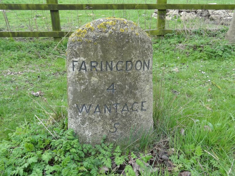
Milestone. Early C19. Limestone painted white with black lettering.
Faringdon/4/Wantage/5.
Listing NGR: SU3433692650
External links are from the relevant listing authority and, where applicable, Wikidata. Wikidata IDs may be related buildings as well as this specific building. If you want to add or update a link, you will need to do so by editing the Wikidata entry.


Other nearby listed buildings
