Approximate Location Map
Large Map »
Latitude: 51.5878 / 51°35'15"N
Longitude: -1.4307 / 1°25'50"W
OS Eastings: 439538
OS Northings: 187810
OS Grid: SU395878
Mapcode National: GBR 6Y5.K28
Mapcode Global: VHC12.5C05
Plus Code: 9C3WHHQ9+4P
Entry Name: St Michael's House
Listing Date: 21 December 1978
Grade: II
Source: Historic England
Source ID: 1048526
English Heritage Legacy ID: 251262
ID on this website: 101048526
Location: Wantage, Vale of White Horse, Oxfordshire, OX12
County: Oxfordshire
District: Vale of White Horse
Civil Parish: Wantage
Built-Up Area: Wantage
Traditional County: Berkshire
Lieutenancy Area (Ceremonial County): Oxfordshire
Tagged with: House
WANTAGE PRIORY ROAD
SU3987 (West side)
7/163 St. Michael's House
21/12/78
GV II
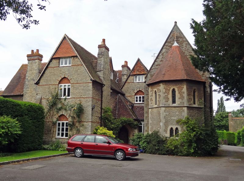
Retreat house for sisterhood of St. Mary the Virgin, now flats. 1855, by William
White. Coursed and dressed limestone rubble with flush red brick bands, and
limestone ashlar dressings; old tile roof; brick stacks. Asymmetrical plan, with
east chapel. 2 storeys to left, 2 storeys and attic to gable ends; 4-window
range. Asymmetrical elevation. Porch with pyramidal roof has moulded pointed
doorway, with alternately brick and limestone ashlar arch above. Recessed gable
end to right. Similar left gable end brought forward and attached at right
angles to left wing 2-window range. Pointed arches of alternate red brick and
limestone ashlar over C20 casements. Gabled roof; lateral and ridge stacks.
Similar style to rear left and right wings with 3-light Geometrical style wood
casements. Chapel to right of front in similar materials has apsidal east end by
A.B. Allin, 1888; side walls have 2-light Geometrical style windows, offset
buttresses and 3-light chamfered mullioned square-headed window each side;
Kentish-tracery quatrefoil light to rear. Gabled roof.
(Buildings of England: Berkshire, p.254; National Monuments Record,
BB79/6600,6601).
Listing NGR: SU3953887810
External links are from the relevant listing authority and, where applicable, Wikidata. Wikidata IDs may be related buildings as well as this specific building. If you want to add or update a link, you will need to do so by editing the Wikidata entry.


Other nearby listed buildings
