Approximate Location Map
Large Map »
Latitude: 51.6251 / 51°37'30"N
Longitude: -1.3182 / 1°19'5"W
OS Eastings: 447293
OS Northings: 192027
OS Grid: SU472920
Mapcode National: GBR 7Z8.3JT
Mapcode Global: VHCYD.3FG2
Plus Code: 9C3WJMGJ+2P
Entry Name: Home Farmhouse
Listing Date: 9 February 1966
Last Amended: 19 February 1988
Grade: II*
Source: Historic England
Source ID: 1052749
English Heritage Legacy ID: 251359
ID on this website: 101052749
Location: Steventon, Vale of White Horse, Oxfordshire, OX13
County: Oxfordshire
District: Vale of White Horse
Civil Parish: Steventon
Built-Up Area: Steventon
Traditional County: Berkshire
Lieutenancy Area (Ceremonial County): Oxfordshire
Church of England Parish: Steventon
Church of England Diocese: Oxford
Tagged with: Farmhouse
STEVENTON MILTON LANE
SU4792 (South side)
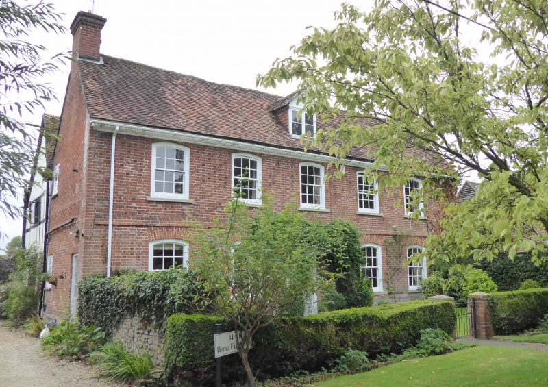
11/52 Nos.14/16 (Home Farmhouse)
09/02/66 (Formerly listed as No.16.
Farmhouse)
GV II*
Farmhouse. C14 cross-wing to rear; c.1600 hall range to rear, and kitchen to end
of cross-wing; early C18 front range. Coursed squared stone plinth; red brick
with flared headers in Flemish bond; old plain-tile roof; brick end stacks
2-storeys and attic; 5-window range. 6-panel part-glazed door to centre with
overlight and C20 segmental wood hood. C20 segmental-headed 12-pane horned
sashes to ground floor with cambered brick heads. Flat brick band between ground
and first floors. Segmental-headed 12-pane unhorned sashes to first floor with
cambered brick heads. Wood dentil cornice to eaves. Gabled full dormer to centre
with 2-light casement. Interior: C18 straight-flight staircase in front range.
2-bay crown-post roof to cross-wing at rear.
("Smaller Domestic Architecture and Society in North Berkshire, c.1300-c.1650
with special reference to Steventon" by C.R.J. Currie (Oxford Univ.Ph.D. thesis
1976))
Listing NGR: SU4729392027
External links are from the relevant listing authority and, where applicable, Wikidata. Wikidata IDs may be related buildings as well as this specific building. If you want to add or update a link, you will need to do so by editing the Wikidata entry.


Other nearby listed buildings
