Approximate Location Map
Large Map »
Latitude: 51.621 / 51°37'15"N
Longitude: -1.3282 / 1°19'41"W
OS Eastings: 446606
OS Northings: 191564
OS Grid: SU466915
Mapcode National: GBR 7Z8.71T
Mapcode Global: VHCYC.XJQ6
Plus Code: 9C3WJMCC+9P
Entry Name: The Old Vicarage
Listing Date: 6 August 1952
Last Amended: 19 February 1988
Grade: II
Source: Historic England
Source ID: 1284705
English Heritage Legacy ID: 251389
ID on this website: 101284705
Location: Steventon, Vale of White Horse, Oxfordshire, OX13
County: Oxfordshire
District: Vale of White Horse
Civil Parish: Steventon
Built-Up Area: Steventon
Traditional County: Berkshire
Lieutenancy Area (Ceremonial County): Oxfordshire
Church of England Parish: Steventon
Church of England Diocese: Oxford
Tagged with: Clergy house
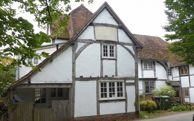
STEVENTON THE CAUSEMAY
SU4691 (South side)
12/77 Nos.l03 (The Old Vicarage) and
06/08/52 107
(Formerly listed as No.103)
GV II
Includes those parts formerly separately listed as Nos.105 and l07. Vicarage,
now dwellings. Early C14 cross-wing to right; mid Cl6 main range and
cross-wing to left, some C17 alterations. Brick plinth; large timber-framing
with rendered infill; old plain-tile complex roof; brick ridge stack to left of
central range. U-shaped plan. 2-storey, 2-bay central range with 2-storey
cross-wings to left and right. Sash doors to left return of right cross-wing and
to right return of left cross-wing. irregular fenestration of casements except
wooden oriel window to first floor left of central range. Queen-post roof truss
to gable end of left cross-wing. Crown-post roof truss to gable end of right
cross-wing. Rear: C17 wood cross-windows to first floor right. Interiors not
inspected.
("Smaller Domestic Architecture and Society in North Berkshire; c.1300-c.1650
with special reference to Steventon by C.R.J. Currie (Ph.D thesis, oxen 1976)
Listing NGR: SU4660691564
External links are from the relevant listing authority and, where applicable, Wikidata. Wikidata IDs may be related buildings as well as this specific building. If you want to add or update a link, you will need to do so by editing the Wikidata entry.


Other nearby listed buildings
