Approximate Location Map
Large Map »
Latitude: 51.6394 / 51°38'21"N
Longitude: -1.2782 / 1°16'41"W
OS Eastings: 450048
OS Northings: 193644
OS Grid: SU500936
Mapcode National: GBR 7Z4.1PS
Mapcode Global: VHCYD.S2N2
Plus Code: 9C3WJPQC+QP
Entry Name: Southfield Farmhouse
Listing Date: 19 February 1988
Grade: II
Source: Historic England
Source ID: 1182427
English Heritage Legacy ID: 251444
ID on this website: 101182427
Location: Sutton Courtenay, Vale of White Horse, Oxfordshire, OX14
County: Oxfordshire
District: Vale of White Horse
Civil Parish: Sutton Courtenay
Built-Up Area: Sutton Courtenay
Traditional County: Berkshire
Lieutenancy Area (Ceremonial County): Oxfordshire
Church of England Parish: Sutton Courtenay
Church of England Diocese: Oxford
Tagged with: Farmhouse
SU5093
9/128
SUTTON COURTENAY
HIGH STREET
(West side)
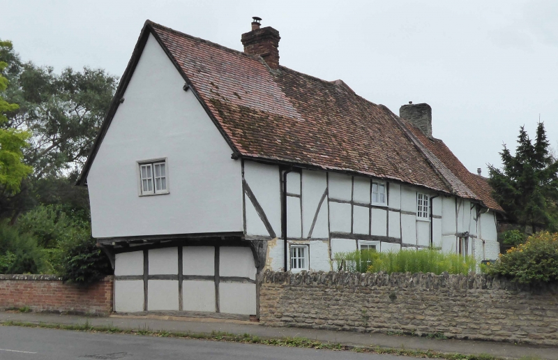
No.66 (Southfield Farmhouse)
II
Farmhouse, now house C15 jettied bay to street end; C16 range to west end; C17
central range, and cross-wing to centre. Roughcast on timber-framing to right;
large timber-framing to left and to cross-wing with painted brick infill: old
plain-tile roof; brick ridge stack to right of centre; stone ridge stack to left
of centre; brick end stack to cross-wing. 2-storey, 5-bay range at right-angles
to street with 2-storey, 5-bay cross-wing to centre. Stable door to left of
centre. Irregular fenestration of casements, including Ipswich window to first
floor right return of cross-wing. C16 wood mullioned window to first floor left.
Right return: first floor jettied. Interior: C20 straight-flight staircase from
ground to first floor. Queen post roof, C15 portion noted as having remains of
dove boxes to gable end, Wood store to left end formerly floored; part of former
smoke by visible to roof, massive stone stack inserted into smoke bay.
Listing NGR: SU5004893644
External links are from the relevant listing authority and, where applicable, Wikidata. Wikidata IDs may be related buildings as well as this specific building. If you want to add or update a link, you will need to do so by editing the Wikidata entry.


Other nearby listed buildings
