Approximate Location Map
Large Map »
Latitude: 51.7848 / 51°47'5"N
Longitude: -1.4762 / 1°28'34"W
OS Eastings: 436229
OS Northings: 209701
OS Grid: SP362097
Mapcode National: GBR 6VS.5KW
Mapcode Global: VHC02.CDGM
Plus Code: 9C3WQGMF+WG
Entry Name: Barn Range and Attached Walls, Granary, Outbuildings and Stables Approximately 50 Metres North North East of Manor Farmhouse
Listing Date: 3 March 1988
Grade: II
Source: Historic England
Source ID: 1212301
English Heritage Legacy ID: 252635
ID on this website: 101212301
Location: Cogges, West Oxfordshire, OX28
County: Oxfordshire
District: West Oxfordshire
Civil Parish: Witney
Built-Up Area: Witney
Traditional County: Oxfordshire
Lieutenancy Area (Ceremonial County): Oxfordshire
Church of England Parish: Cogges
Church of England Diocese: Oxford
Tagged with: Barn
WITNEY COGGES
SP3609
8/81 Barn range and attached walls,
granary, outbuildings and
stables approx. 50m. NNE of
Manor Farmhouse
GV II
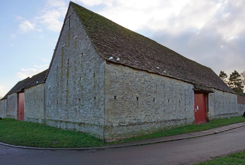
Barns, now part of Cogges Farm Museum. Early C18 and later C18 to right, Coursed
limestone rubble with ashlar quoins and ventilation holes; gabled stone slate
roof. L-plan with front right barn. Barn on left has gabled midstrey with C18
plank doors and adjoining C19 lean-to. Barn on right has hipped midstrey.
Interior: early C18 barn on left has stone-flag threshing floor, and 7-bay
collar-truss roof with butt purlins and C20 bracing; 5-bay collar-truss roof
with butt purlins in later C18 barn on right. Subsidiary features: to left are
mid C19 cartshed and shelter shed and C18 two-storey former granary to left.
Granary of coursed limestone rubble with gabled stone slate roof: limestone
rubble wall projects approximately 2 metres to front of front right corner. C18
L-shaped limestone rubble wall of approximately 10 x 12 metres encloses yard in
front of barn. Mid/late C18 stables to front right gable, of similar materials:
timber lintels over C20 and C18 plank doors; interior has central plank
partition and 2-bay collar-truss roof with butt purlins.
Listing NGR: SP3622909697
External links are from the relevant listing authority and, where applicable, Wikidata. Wikidata IDs may be related buildings as well as this specific building. If you want to add or update a link, you will need to do so by editing the Wikidata entry.


Other nearby listed buildings
