Approximate Location Map
Large Map »
Latitude: 51.8401 / 51°50'24"N
Longitude: -1.4019 / 1°24'6"W
OS Eastings: 441306
OS Northings: 215890
OS Grid: SP413158
Mapcode National: GBR 7WG.LD4
Mapcode Global: VHBZX.N08Q
Plus Code: 9C3WRHRX+27
Entry Name: Church House
Listing Date: 29 June 1988
Grade: II
Source: Historic England
Source ID: 1053008
English Heritage Legacy ID: 252715
ID on this website: 101053008
Location: Combe, West Oxfordshire, OX29
County: Oxfordshire
District: West Oxfordshire
Civil Parish: Combe
Built-Up Area: Combe
Traditional County: Oxfordshire
Lieutenancy Area (Ceremonial County): Oxfordshire
Church of England Parish: Combe Longa
Church of England Diocese: Oxford
Tagged with: House
COMBE CHURCH WALK
SP4115 (East side)
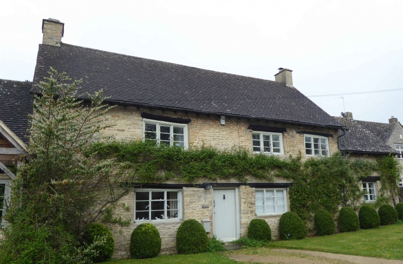
17/61 Church House
- II
House. Early C17, with later alterations. Coursed limestone rubble; gabled C20
concrete tile roof; stone end stacks. 2-unit plan. 2 storeys; 3-window range.
Dentilled timber lintels over C20 central door and C20 casements; timber lintel
over C20 window to right.
Listing NGR: SP4130615890
External links are from the relevant listing authority and, where applicable, Wikidata. Wikidata IDs may be related buildings as well as this specific building. If you want to add or update a link, you will need to do so by editing the Wikidata entry.


Other nearby listed buildings
