Approximate Location Map
Large Map »
Latitude: 51.7359 / 51°44'9"N
Longitude: -1.5857 / 1°35'8"W
OS Eastings: 428708
OS Northings: 204218
OS Grid: SP287042
Mapcode National: GBR 5TX.1Y6
Mapcode Global: VHC06.GMLL
Plus Code: 9C3WPCP7+9P
Entry Name: The Old Inn
Listing Date: 12 September 1955
Last Amended: 4 May 1989
Grade: II
Source: Historic England
Source ID: 1053519
English Heritage Legacy ID: 253469
ID on this website: 101053519
Location: Black Bourton, West Oxfordshire, OX18
County: Oxfordshire
District: West Oxfordshire
Civil Parish: Black Bourton
Traditional County: Oxfordshire
Lieutenancy Area (Ceremonial County): Oxfordshire
Church of England Parish: Black Bourton
Church of England Diocese: Oxford
Tagged with: Inn
SP2804-2904 CARTERTON AND BLACK BOURTON BURFORD ROAD
(West side)
Black Bourton
10/157 The Old Inn
12/09/55 (Formerly listed as Cottage
opposite and to the West of
Mill Farm Cottage)
GV II
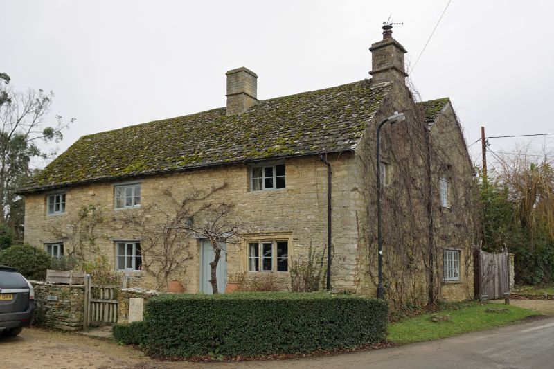
Former inn, now house. Originally a C17 single range, with rear outshots added
and front raised C18-early C19. Outshots altered to parallel rear range c.1950.
Incorporates carved stone fragments, some from Bourton Place, former manor house
of the Hungerford family, demolished c.1800. Coursed rubble limestone, 2-span
roof of stone slates, rebuilt rubble stone chimneys to right and between right
bays. 2 storeys, 3 bays. 3-light wooden casements with horizontal glazing bars,
renewed C20, all with wooden lintels. Ground floor lintels are old, upper
lintels renewed. Ground floor of right bay has 3-light window with
hollow-chamfered stone mullions and Tudor hoodmould, possibly not original to
house. C20 board door with C20 wooden lintel between right bays. Over door is a
C18 carved stone tablet carved with military trophy, almost certainly from
Bourton Place. Another small square tablet below eaves between left bays carries
simple motifs from the Hungerford arms. Below eaves to centre is a tablet dated
ITM 1655, which may be original to house, but if so was re-set when front
raised. Interior has C17 stop-chamfered spine beam in left bay, winder stair in
right bay on axis with stack, and altered trusses with cranked principals.
Listing NGR: SP2871004218
External links are from the relevant listing authority and, where applicable, Wikidata. Wikidata IDs may be related buildings as well as this specific building. If you want to add or update a link, you will need to do so by editing the Wikidata entry.


Other nearby listed buildings
