Approximate Location Map
Large Map »
Latitude: 51.6893 / 51°41'21"N
Longitude: -1.6384 / 1°38'18"W
OS Eastings: 425094
OS Northings: 199014
OS Grid: SU250990
Mapcode National: GBR 5VF.0LW
Mapcode Global: VHC0C.KS6T
Plus Code: 9C3WM9Q6+PM
Entry Name: Barn and Cowhouse Approximately 75 Metres South East of Manor Farmhouse
Listing Date: 12 September 1955
Last Amended: 30 March 1989
Grade: II
Source: Historic England
Source ID: 1053379
English Heritage Legacy ID: 253830
ID on this website: 101053379
Location: Kelmscott, West Oxfordshire, GL7
County: Oxfordshire
District: West Oxfordshire
Civil Parish: Kelmscott
Traditional County: Oxfordshire
Lieutenancy Area (Ceremonial County): Oxfordshire
Church of England Parish: Broadwell with Kelmscott
Church of England Diocese: Oxford
Tagged with: Barn
KELMSCOTT
SU2499-2599
10/78 Barn and cowhouse approx. 75m
SE of Manor Farmhouse
12.9.55 (Formerly listed as part of
Manor Farmhouse with Barn and
Cawsheds to SE. Dovecote. Barn
to N, Barn and Cowsheds to SW)
- II
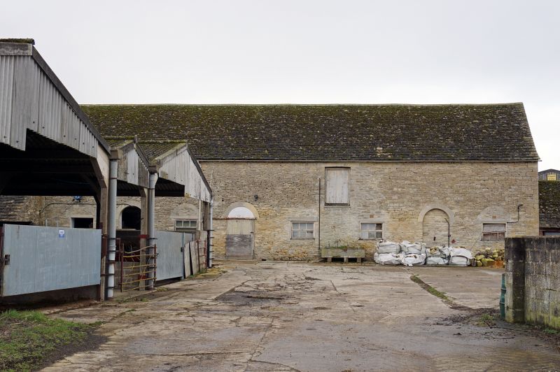
Barn and cowhouse. Early C19 remodelling of earlier barn. Roughly coursed
limestone rubble with alternating angle quoins; stone slate roof. Long building
apparently truncated and rebuilt to left of cart entrance on left. 2 levels.
Five early. C19 round-headed doorways to right of catslide outshut in angle to
right of hip-roofed cart entrance, third from left infilled with C20 centre-hung
casement inserted and fourth from left retaining fanlight. Fifth doorway from
left is also infilled with two C20 centre-hung casements between it and fourth
doorway from left and another to right with round-headed relieving arch. Plank
door with cambered head directly below eaves between 2 casements between fourth
and fifth doorways from left. Opposing doorway to cart entrance in back wall.
Interior. Inserted full-length loft to right of cart entrance. Double-purlin
collar and tie beam roof. Ground floor converted into milking parlour in
mid-C20,
[2373]
Listing NGR: SU2509499014
External links are from the relevant listing authority and, where applicable, Wikidata. Wikidata IDs may be related buildings as well as this specific building. If you want to add or update a link, you will need to do so by editing the Wikidata entry.


Other nearby listed buildings
