Approximate Location Map
Large Map »
Latitude: 51.9144 / 51°54'51"N
Longitude: -1.6257 / 1°37'32"W
OS Eastings: 425843
OS Northings: 224053
OS Grid: SP258240
Mapcode National: GBR 5RJ.XFT
Mapcode Global: VHBZD.R4XR
Plus Code: 9C3WW97F+QP
Entry Name: Manor Farmhouse
Listing Date: 15 May 1989
Grade: II
Source: Historic England
Source ID: 1200093
English Heritage Legacy ID: 254061
ID on this website: 101200093
Location: Kingham, West Oxfordshire, OX7
County: Oxfordshire
District: West Oxfordshire
Civil Parish: Kingham
Built-Up Area: Kingham
Traditional County: Oxfordshire
Lieutenancy Area (Ceremonial County): Oxfordshire
Church of England Parish: Kingham and Daylesford
Church of England Diocese: Oxford
Tagged with: Farmhouse
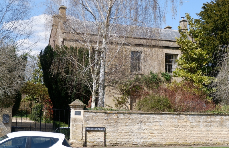
KINGHAM WEST STREET
SP2424-2524 (North-west side)
15/158 Manor Farmhouse
GV II
Farmhouse, now house. Dated 1801 incorporating parts of an earlier building.
Regularly coursed and dressed limestone rubble with ashlar front; double-span
slate roof with coped verges, parapet and eaves cornice. Double-depth plan. 2
storeys on plinth. 3-window front, 16-paned horned glazing bar sashes, except
centre on first floor 9-paned in projecting surround. Central entrance; C20
half-glazed door in plain surround with bracketed segmental stone hood. Integral
end stacks with moulded dripstones and capping to both ranges. Cellar to left
gable end has boarded door with cambered head approached by straight flight of
steps. Rear range has chamfered 4-light mullion window on first floor to right
gable end and chamfered 2-light mullion window to attic. Datestone "1801" above
rainwater head at junction with front range. Low 2-storey gabled range at
right-angles to rear on right has coped verges and integral end stack. Interior.
Dog-leg staircase in central stone-flagged entrance hall has stick balusters to
open string and ramped handrail. Panelled window shutters, doors, plaster
cornices and elm floor boards to front range. Left room of rear range has
iriglenook fireplace with chamfered wood lintel and oak winder staircase,
continuing to attic, in cupboard-like projection to left. Projecting rear range
has chamfered cross beam with stepped ogee stops and triple segmental-arched
fireplace to end wall. Central arch cut through by C20 toilet but smaller brick
arch survives to each side, left with semi-circular cast-iron cauldron fed by
flues and pipes from central fireplace: probably used for tallow making. First
floor has collar truss roof in 2 bays with infilled doorway formerly connecting
with rear range of main house. This has collar truss roof with double
butt-purlins to both ranges and initials and date "SB 1801" carved on one of tie
beams to front range. Dividing wall between ranges seems originally to have been
external, in which case the rear range is probably earlier, the front range
being added when the original part was encased in new stonework and reroofed in
1801. C20 lean-to in angle between rear range and projecting range to rear is
not of special architectural interest.
[2607]
Listing NGR: SP2584324053
External links are from the relevant listing authority and, where applicable, Wikidata. Wikidata IDs may be related buildings as well as this specific building. If you want to add or update a link, you will need to do so by editing the Wikidata entry.


Other nearby listed buildings
