Approximate Location Map
Large Map »
Latitude: 52.4576 / 52°27'27"N
Longitude: -2.3547 / 2°21'16"W
OS Eastings: 375995
OS Northings: 284468
OS Grid: SO759844
Mapcode National: GBR 09B.ZDB
Mapcode Global: VH91D.4HJB
Plus Code: 9C4VFJ5W+34
Entry Name: 16 and 17, Centre Place
Listing Date: 9 March 1970
Grade: II
Source: Historic England
Source ID: 1053195
English Heritage Legacy ID: 254287
ID on this website: 101053195
Location: Alveley, Shropshire, WV15
County: Shropshire
Civil Parish: Alveley
Built-Up Area: Alveley
Traditional County: Shropshire
Lieutenancy Area (Ceremonial County): Shropshire
Church of England Parish: Alveley
Church of England Diocese: Hereford
Tagged with: Building
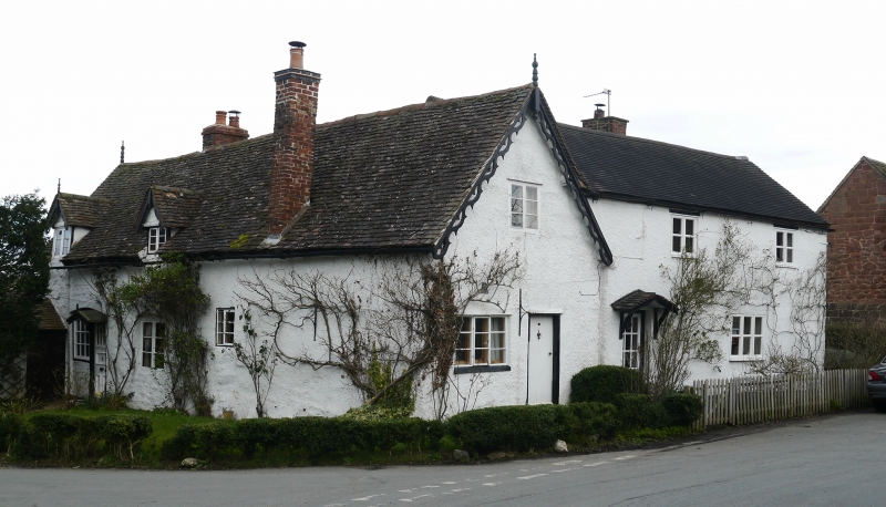
1.
1954 ALVELEY ALVELEY
CENTRE PLACE
Nos 16 and 17
SO 78 SE 33/9 9.3.70.
II GV
2.
Probably C18. Roughcast; plaintile roofs; brick stacks; 2 gabled dormers
to No 16; plain doors under small gabled hoods. Single-storey plus attics;
various casement windows.
Church of St Mary. Churchyard Cross and walls, and all the buildings in
Centre Place form a group.
Listing NGR: SO7599684468
External links are from the relevant listing authority and, where applicable, Wikidata. Wikidata IDs may be related buildings as well as this specific building. If you want to add or update a link, you will need to do so by editing the Wikidata entry.


Other nearby listed buildings
