Approximate Location Map
Large Map »
Latitude: 52.5358 / 52°32'8"N
Longitude: -2.4203 / 2°25'13"W
OS Eastings: 371588
OS Northings: 293189
OS Grid: SO715931
Mapcode National: GBR BZ.F6W4
Mapcode Global: VH90Z.0JBD
Plus Code: 9C4VGHPH+8V
Entry Name: 25, High Street
Listing Date: 1 February 1974
Grade: II
Source: Historic England
Source ID: 1054001
English Heritage Legacy ID: 254429
ID on this website: 101054001
Location: Bridgnorth, Shropshire, WV16
County: Shropshire
Civil Parish: Bridgnorth
Built-Up Area: Bridgnorth
Traditional County: Shropshire
Lieutenancy Area (Ceremonial County): Shropshire
Church of England Parish: Bridgnorth
Church of England Diocese: Hereford
Tagged with: Building
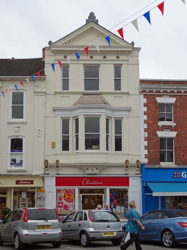
1.
1954 BRIDGNORTH
HIGH STREET
(West Side)
No 25
SO 79 SW 2/92
II GV
2.
Early to mid C19. Stucco; 3 storeys; pediment and three-light bay window
with side lights, both with acroteria; enriched cornice at 1st floor with
foliated consoles. Modern shop front.
Nos 23 to 37 (consec) form a group
Listing NGR: SO7158893189
External links are from the relevant listing authority and, where applicable, Wikidata. Wikidata IDs may be related buildings as well as this specific building. If you want to add or update a link, you will need to do so by editing the Wikidata entry.


Other nearby listed buildings
