Approximate Location Map
Large Map »
Latitude: 52.5353 / 52°32'7"N
Longitude: -2.4187 / 2°25'7"W
OS Eastings: 371694
OS Northings: 293133
OS Grid: SO716931
Mapcode National: GBR BZ.F78N
Mapcode Global: VH90Z.1J5S
Plus Code: 9C4VGHPJ+4G
Entry Name: The Court
Listing Date: 18 July 1949
Grade: II*
Source: Historic England
Source ID: 1367488
English Heritage Legacy ID: 254444
ID on this website: 101367488
Location: Bridgnorth, Shropshire, WV16
County: Shropshire
Civil Parish: Bridgnorth
Built-Up Area: Bridgnorth
Traditional County: Shropshire
Lieutenancy Area (Ceremonial County): Shropshire
Church of England Parish: Bridgnorth
Church of England Diocese: Hereford
Tagged with: Building
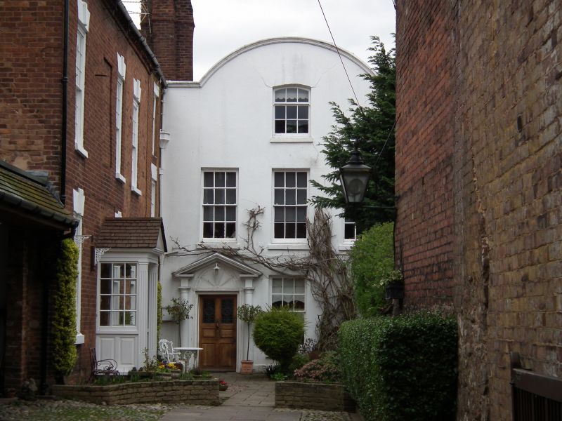
1.
1954 BRIDGNORTH
HIGH STREET
(East Side)
No 48 (The Court)
SO 79 SW 2/107 18.7.49.
II*
2.
Early C18. Stucco; 3 storeys; 3 sash windows; curved gable with moulded
coping; pedimeted wood doorcase with inset shell tympanum and Tuscan
columns and later 6-panel door. Good panelled hall and staircase.
Listing NGR: SO7169493133
External links are from the relevant listing authority and, where applicable, Wikidata. Wikidata IDs may be related buildings as well as this specific building. If you want to add or update a link, you will need to do so by editing the Wikidata entry.


Other nearby listed buildings
