Approximate Location Map
Large Map »
Latitude: 52.5362 / 52°32'10"N
Longitude: -2.4198 / 2°25'11"W
OS Eastings: 371624
OS Northings: 293231
OS Grid: SO716932
Mapcode National: GBR BZ.F70N
Mapcode Global: VH90Z.0JM3
Plus Code: 9C4VGHPJ+F3
Entry Name: 71 and 72, High Street
Listing Date: 1 February 1974
Grade: II
Source: Historic England
Source ID: 1177652
English Heritage Legacy ID: 254454
ID on this website: 101177652
Location: Bridgnorth, Shropshire, WV16
County: Shropshire
Civil Parish: Bridgnorth
Built-Up Area: Bridgnorth
Traditional County: Shropshire
Lieutenancy Area (Ceremonial County): Shropshire
Church of England Parish: Bridgnorth
Church of England Diocese: Hereford
Tagged with: Building
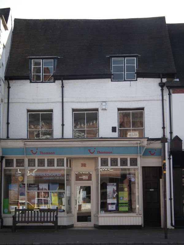
1.
1954 BRIDGNORTH
HIGH STRIET
(East Side)
Nos 71 and 72
SO 79 SW 2/117
II GV
2.
C18 and later. Painted brick; 2 storeys and attic; 3 sash windows (no
glazing bars) with flat brick arches; 2 modern or restored dormers breaking
above eaves; band; bold lined eaves; tiles. Late C19 shop fronts. Included
for group value.
No 65 & Nos 71 to 73 (consec) form a group
Listing NGR: SO7162493231
External links are from the relevant listing authority and, where applicable, Wikidata. Wikidata IDs may be related buildings as well as this specific building. If you want to add or update a link, you will need to do so by editing the Wikidata entry.


Other nearby listed buildings
